File:Algeria-map.png
No higher resolution available.
Algeria-map.png (330 × 355 pixels, file size: 12 KB, MIME type: image/png)
Captions
Captions
Add a one-line explanation of what this file represents
Summary edit
Transferred from ja.wikipedia to Commons by Maksim.
The original description page was here. All following user names refer to ja.wikipedia.
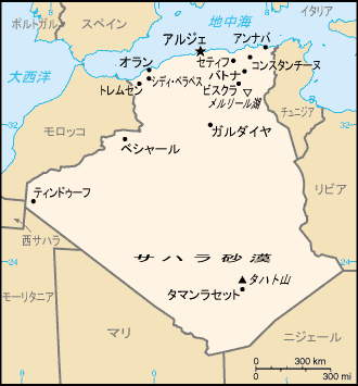
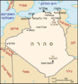
アルジェリアの地図 - CIA The World Factbook archive copy at the Wayback MachineのPD画像を日本語化
掲載地名: アルジェ、アンナバ、オラン、ガルダイヤ、コンスタンチーヌ、シディ・ベラベス、セティフ、タマンラセット、ティンドゥーフ、トレムセン、バトナ、ビスクラ、ベシャール、サハラ砂漠、タハト山、メルリール湖
| This file is licensed under the Creative Commons Attribution-Share Alike 3.0 Unported license. Subject to disclaimers. | ||
| ||
| This licensing tag was added to this file as part of the GFDL licensing update. |

|
Permission is granted to copy, distribute and/or modify this document under the terms of the GNU Free Documentation License, Version 1.2 or any later version published by the Free Software Foundation; with no Invariant Sections, no Front-Cover Texts, and no Back-Cover Texts. A copy of the license is included in the section entitled GNU Free Documentation License. Subject to disclaimers. |
| date/time | username | edit summary |
|---|---|---|
| 2005年1月22日 (土) 15:02 | ja:利用者:Oxhop | (ライセンス情報、掲載地名Index) |
| 2004年6月6日 (日) 06:32 | ja:利用者:Gbr3 | (アルジェリアの地図(英語版から)) |
- Other versions
[]
-
 blank PNG
 -
 blank SVG
 -
 English
 -
 français
 -
 français
 -
 lietuvių
 -
 עברית
עברית -
 čeština
 -
 svenska
 -
 español
 -
 العربية
 -
 日本語
日本語 -
 Afrikaans


Original upload log edit
凡例:(最新)= 最新版の画像、(削除)= この版の画像を削除、(差戻)= この版の画像に差し戻す
アップロードされた画像を見るには日付をクリックします。
- (削除) (最新版) 2005年1月22日 (土) 15:00 . . ja:利用者:Oxhop Oxhop ( ja:利用者‐会話:Oxhop ノート) . . 330×355 (12096 バイト) (アルジェリアの地図 - CIA World Factbookより日本語化)
- (削除) (差戻) 2004年6月6日 (日) 06:32 . . ja:利用者:Gbr3 Gbr3 ( ja:利用者‐会話:Gbr3 ノート) . . 330×355 (9409 バイト) (アルジェリアの地図(英語版から))
File history
Click on a date/time to view the file as it appeared at that time.
| Date/Time | Thumbnail | Dimensions | User | Comment | |
|---|---|---|---|---|---|
| current | 11:50, 29 January 2006 | | 330 × 355 (12 KB) | Maksim (talk | contribs) | La bildo estas kopiita de wikipedia:ja. La originala priskribo estas: アルジェリアの地図 - [http://www.cia.gov/cia/publications/factbook/ CIA The World Factbook]のPD画像を日本語化 掲載地名: アルジ� |
You cannot overwrite this file.
File usage on Commons
The following 13 pages use this file:
- File:000 Algjeria harta.PNG
- File:Ag-map-HE.png
- File:Ag-map - 2.png
- File:Ag-map LT.png
- File:Algeria-map.png
- File:Algeria CIA map.png
- File:Algeria map-FR.png
- File:Algeria map-es.jpg
- File:Algeria map-sv.png
- File:Algeria map Arabic.png
- File:Algeriekaart.png
- File:Carte-algerie.png
- Template:Other versions/Algeria map
File usage on other wikis
The following other wikis use this file:
- Usage on ja.wikipedia.org