File:Algeria Saharan Wadis.jpg

Size of this preview: 600 × 600 pixels. Other resolutions: 240 × 240 pixels | 480 × 480 pixels | 768 × 768 pixels | 1,024 × 1,024 pixels | 2,048 × 2,048 pixels | 3,096 × 3,096 pixels.
Original file (3,096 × 3,096 pixels, file size: 3.16 MB, MIME type: image/jpeg)
File information
Structured data
Captions
Captions
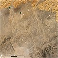
Saharan Wadis in Algeria
Summary edit
| DescriptionAlgeria Saharan Wadis.jpg |
English: The Sahara Desert covers most of the North African country of Algeria. Rainfall is scarce, and it comes and goes rapidly, flowing through channels called wadis. When dry, as they are in this true-color Landsat Thematic Mapper image from January 1, 1987, the wadis are revealed as pale tracings across the darker brown and gray shades of the desert landscape. In many cases, these wadis end in small pools which have no outlet. The water flows in from the wadis and gradually evaporates, leaving behind salts and other minerals which appear white in this image. At the upper left of the image, a few pools of bright blue-green water are hanging on despite the aridity, their greenish color probably due to high salt and mineral content, or perhaps the growth of algae. |
| Date | |
| Source | https://archive.org/details/VE-IMG-16214 |
| Author | Robert Simmon, NASA GSFC |
Licensing edit
| Public domainPublic domainfalsefalse |
| This file is in the public domain in the United States because it was solely created by NASA. NASA copyright policy states that "NASA material is not protected by copyright unless noted". (See Template:PD-USGov, NASA copyright policy page or JPL Image Use Policy.) |  | |
 |
Warnings:
|
File history
Click on a date/time to view the file as it appeared at that time.
| Date/Time | Thumbnail | Dimensions | User | Comment | |
|---|---|---|---|---|---|
| current | 01:23, 6 June 2022 |  | 3,096 × 3,096 (3.16 MB) | Epolk (talk | contribs) | Higher resolution image |
| 01:21, 6 June 2022 |  | 540 × 540 (66 KB) | Epolk (talk | contribs) | Uploaded a work by Robert Simmon, NASA GSFC from https://archive.org/details/VE-IMG-16214 with UploadWizard |
You cannot overwrite this file.
File usage on Commons
There are no pages that use this file.
Metadata
This file contains additional information such as Exif metadata which may have been added by the digital camera, scanner, or software program used to create or digitize it. If the file has been modified from its original state, some details such as the timestamp may not fully reflect those of the original file. The timestamp is only as accurate as the clock in the camera, and it may be completely wrong.
| Orientation | Normal |
|---|---|
| Horizontal resolution | 72 dpi |
| Vertical resolution | 72 dpi |
| Software used | Adobe Photoshop 7.0 |
| File change date and time | 10:53, 19 September 2002 |
| Color space | Uncalibrated |
| IIM version | 2 |