File:All Saints church in Snetterton - rood screen - geograph.org.uk - 1762887.jpg

Size of this preview: 450 × 600 pixels. Other resolutions: 180 × 240 pixels | 480 × 640 pixels.
Original file (480 × 640 pixels, file size: 127 KB, MIME type: image/jpeg)
Captions
Captions
Add a one-line explanation of what this file represents
Summary
edit
| Description |
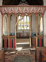
English: All Saints church in Snetterton - rood screen. The church of All Saints > 1762865 is situated beside Sallow Lane, adjoining Hall Farm which is the site of World Horse Welfare headquarters > 1762463. After becoming redundant in 1978 it served as a sort-of monastery for several years, with Brother Joseph worshipping in the chancel and sleeping in a caravan in the churchyard. The 14th century tower was restored once the building was in the care of the Norfolk Churches Trust. The chancel dates from the 13th century and piscina as well as sedilia are original. The interior was extensively restored in Victorian times and the east window > 1762894 reconstructed in 1857. It contains stained glass by O'Connor which was installed in 1885. One of the south windows > 1762904 is by Cox, Buckley & Son, dating from 1884. The octagonal font > 1762910 is the original one, dating from the 15th century and is contemporary with the (damaged) rood screen > 1762888 which was restored and repainted in Victorian times. The present pews came from the church of St Gregory in Norwich, after the original ones had been moved to St Michael's in Langley. No trace remains of a nearby second church, dedicated to St Andrew, that was situated in the grounds of Hall Farm. |
| Date | |
| Source | From geograph.org.uk |
| Author | Evelyn Simak |
| Attribution (required by the license) | Evelyn Simak / All Saints church in Snetterton - rood screen / |
| Camera location | | View this and other nearby images on: OpenStreetMap |
|---|
_heading:90.00&language=en)
| Object location | | View this and other nearby images on: OpenStreetMap |
|---|
_heading:90.00&language=en)
Licensing
edit

|
This image was taken from the Geograph project collection. See this photograph's page on the Geograph website for the photographer's contact details. The copyright on this image is owned by Evelyn Simak and is licensed for reuse under the Creative Commons Attribution-ShareAlike 2.0 license.
|
This file is licensed under the Creative Commons Attribution-Share Alike 2.0 Generic license.
Attribution: Evelyn Simak
- You are free:
- to share – to copy, distribute and transmit the work
- to remix – to adapt the work
- Under the following conditions:
- attribution – You must give appropriate credit, provide a link to the license, and indicate if changes were made. You may do so in any reasonable manner, but not in any way that suggests the licensor endorses you or your use.
- share alike – If you remix, transform, or build upon the material, you must distribute your contributions under the same or compatible license as the original.
File history
Click on a date/time to view the file as it appeared at that time.
| Date/Time | Thumbnail | Dimensions | User | Comment | |
|---|---|---|---|---|---|
| current | 20:22, 11 March 2011 | | 480 × 640 (127 KB) | GeographBot (talk | contribs) | == {{int:filedesc}} == {{Information |description={{en|1=All Saints church in Snetterton - rood screen The church of All Saints > http://www.geograph.org.uk/photo/1762865 is situated beside Sallow Lane, adjoining Hall Farm which is the site of World Horse |
You cannot overwrite this file.
File usage on Commons
There are no pages that use this file.