File:Alsap Butte south aspect.jpg

Size of this preview: 400 × 600 pixels. Other resolutions: 160 × 240 pixels | 320 × 480 pixels | 512 × 768 pixels | 682 × 1,024 pixels | 1,365 × 2,048 pixels | 2,880 × 4,320 pixels.
Original file (2,880 × 4,320 pixels, file size: 2.52 MB, MIME type: image/jpeg)
Captions
Captions
Add a one-line explanation of what this file represents
Summary
edit
| Description |
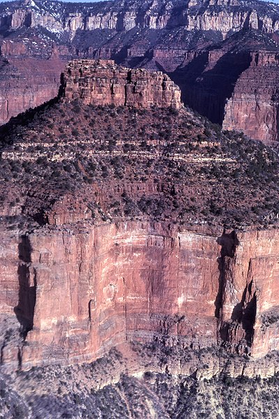
English: Aerial view northwest toward south side of Alsap Butte, upper Nankoweap Canyon. Gray Esplanade Sandstone cliff, overlying red slope of Wescogame Formation, overlying white Manakacha Formation, overlying red ledges of Watahomigi Formation, overlying large gray cliff of Redwall Limestone. |
| Date | |
| Source | https://www.sciencebase.gov/catalog/item/5c75ab1be4b0fe48cb4a5ac3 |
| Author | George Billingsley, U.S. Geological Survey |
| Camera location | | View this and other nearby images on: OpenStreetMap |
|---|
Licensing
edit
This image is in the public domain in the United States because it only contains materials that originally came from the United States Geological Survey, an agency of the United States Department of the Interior. For more information, see the official USGS copyright policy.
|
File history
Click on a date/time to view the file as it appeared at that time.
| Date/Time | Thumbnail | Dimensions | User | Comment | |
|---|---|---|---|---|---|
| current | 11:11, 1 February 2021 | | 2,880 × 4,320 (2.52 MB) | Ron Clausen (talk | contribs) | Uploaded a work by George Billingsley, U.S. Geological Survey from https://www.sciencebase.gov/catalog/item/5c75ab1be4b0fe48cb4a5ac3 with UploadWizard |
You cannot overwrite this file.
File usage on Commons
There are no pages that use this file.
File usage on other wikis
The following other wikis use this file:
- Usage on de.wikipedia.org
- Usage on en.wikipedia.org