File:Altoona City Sections.jpg

Size of this preview: 378 × 600 pixels. Other resolutions: 151 × 240 pixels | 302 × 480 pixels | 484 × 768 pixels | 645 × 1,024 pixels | 1,327 × 2,106 pixels.
Original file (1,327 × 2,106 pixels, file size: 1,023 KB, MIME type: image/jpeg)
Captions
Captions
Add a one-line explanation of what this file represents
Summary edit
| Description |
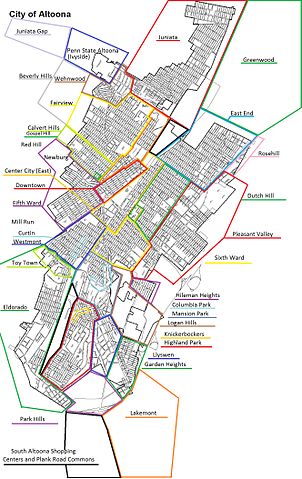
English: Crude map of the Altoona City sections and neighborhoods. The area of drawn streets represents the City borders as of 6/2012. Areas to the West, North, East and Southeast are in Logan Township, and Southwest is Allegheny Township. |
| Date | |
| Source | Own work |
| Author | Csoldner187 |
Licensing edit
I, the copyright holder of this work, hereby publish it under the following license:
This file is licensed under the Creative Commons Attribution-Share Alike 3.0 Unported license.
- You are free:
- to share – to copy, distribute and transmit the work
- to remix – to adapt the work
- Under the following conditions:
- attribution – You must give appropriate credit, provide a link to the license, and indicate if changes were made. You may do so in any reasonable manner, but not in any way that suggests the licensor endorses you or your use.
- share alike – If you remix, transform, or build upon the material, you must distribute your contributions under the same or compatible license as the original.
File history
Click on a date/time to view the file as it appeared at that time.
| Date/Time | Thumbnail | Dimensions | User | Comment | |
|---|---|---|---|---|---|
| current | 00:18, 5 June 2012 | | 1,327 × 2,106 (1,023 KB) | Csoldner187 (talk | contribs) |
You cannot overwrite this file.
File usage on Commons
There are no pages that use this file.