File:Altrheinärme.jpg
No higher resolution available.
Altrheinärme.jpg (392 × 457 pixels, file size: 115 KB, MIME type: image/jpeg)
Captions
Captions
Add a one-line explanation of what this file represents
Summary
edit
| Description |
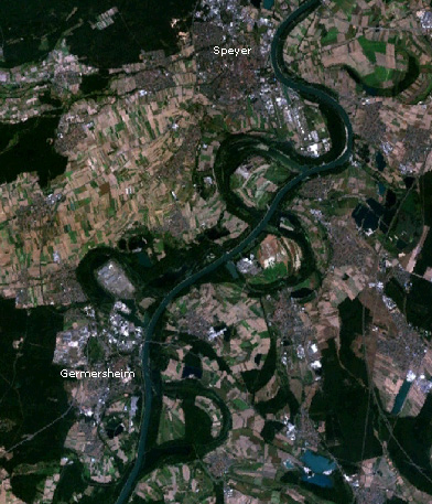
Deutsch: Durch nicht abgeholzte Stromauen auf dem Satellitenbild gut sichtbarer Verlauf des Altrheins zwischen Germersheim und Speyer.
Erstellt mit NASA World Wind. |
| Source | NASA |
| Author | NASA |
Licensing
edit
| This image is in the public domain because it is a screenshot from NASA’s globe software World Wind using a public domain layer, such as Blue Marble, MODIS, Landsat, SRTM, USGS or GLOBE.
|
 |
Original upload log
edit
The original description page was here. All following user names refer to de.wikipedia.
- 2006-04-28 06:47 Texon 392×457× (118270 bytes) Durch nicht abgeholzte Stromauen auf dem Satellitenbild gut sichtbarer Verlauf des Altrheins zwischen [[Germersheim]] und [[Speyer]]. Erstellt mit [[NASA World Wind]].
File history
Click on a date/time to view the file as it appeared at that time.
| Date/Time | Thumbnail | Dimensions | User | Comment | |
|---|---|---|---|---|---|
| current | 18:14, 10 October 2011 | | 392 × 457 (115 KB) | File Upload Bot (Magnus Manske) (talk | contribs) | {{BotMoveToCommons|de.wikipedia|year={{subst:CURRENTYEAR}}|month={{subst:CURRENTMONTHNAME}}|day={{subst:CURRENTDAY}}}} {{Information |Description={{de|Durch nicht abgeholzte Stromauen auf dem Satellitenbild gut sichtbarer Verlauf des Altrheins zwischen [ |
You cannot overwrite this file.
File usage on Commons
There are no pages that use this file.
File usage on other wikis
The following other wikis use this file:
- Usage on de.wikipedia.org
- Usage on en.wikipedia.org
- Usage on eo.wikipedia.org
- Usage on hy.wikipedia.org
- Usage on pl.wikipedia.org
- Usage on www.wikidata.org