File:Amsterdam train map.png

Original file (2,116 × 2,142 pixels, file size: 388 KB, MIME type: image/png)
Captions
Captions
Summary edit
| Description |
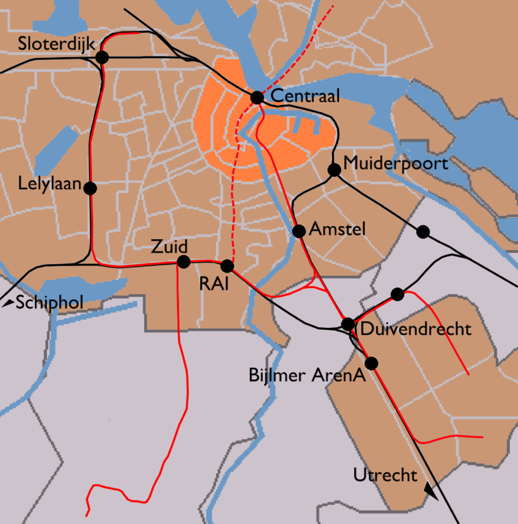
English: Map of Amsterdam's train stations. Greyish orange background denotes the municipality of Amsterdam, bright orange is the Amsterdam-Centrum district. Black lines are railways and red lines are metro lines. Dashed red line is a metro line under construction (to be opened 2013). Black dots are the train stations.
|
| Date | |
| Source | Image modified by me, taken from Wikipedia Commons (Image:Outline map Amsterdam metro 2.PNG), which uses data from (and copyrighted by) the Dutch Centraal Bureau voor de Statistiek, which "allows anyone to use it for any purpose, provided that the copyright holder is properly attributed. Redistribution, derivative work, commercial use, and all other use is permitted." The map on Wikipedia was made by user Michiel1972, who placed his contribution in the public domain. I am doing the same for my modifications. |
| Author | CBS, Michiel1972, me ((WT-shared) Mtcv) |
| Permission (Reusing this file) |
attribution required; PD This image is (in part or entirely) based on geographical data from Statistics Netherlands (Centraal Bureau voor de Statistiek). Digital geometry files in ESRI format can be downloaded from their website [1]. In particular, boundary data of statistical districts is based on either the Wijk- en buurtkaart 2005, or the Wijk- en buurtkaart 2003 ("CBS/TOPgrenzen"). Data on localities (bevolkingskernen) are from the publication Bevolkingskernen in Nederland 2001. Conditions of use (in Dutch):
|
Licensing edit
| This work has been released into the public domain by its author, User: (WT-shared) Mtcv at wts wikivoyage. This applies worldwide. In some countries this may not be legally possible; if so: User: (WT-shared) Mtcv at wts wikivoyage grants anyone the right to use this work for any purpose, without any conditions, unless such conditions are required by law.
|
Original upload log edit
| This file was imported from Wikivoyage WTS. |
- 2007-12-03 14:03 (WT-shared) Mtcv[dead link] 2116×2142 (397547 bytes) {{Information |description=Map of Amsterdam's train stations. |source=Image modified by me, taken from Wikipedia Commons ([http://commons.wi (Import from wikitravel.org/shared)
File history
Click on a date/time to view the file as it appeared at that time.
| Date/Time | Thumbnail | Dimensions | User | Comment | |
|---|---|---|---|---|---|
| current | 20:08, 17 November 2012 | | 2,116 × 2,142 (388 KB) | MGA73bot2 (talk | contribs) | {{BotMoveToCommons|wts.oldwikivoyage|year={{subst:CURRENTYEAR}}|month={{subst:CURRENTMONTHNAME}}|day={{subst:CURRENTDAY}}}} == {{int:filedesc}} == {{Information |description=Map of Amsterdam's train stations. Greyish orange background denotes the munic... |
You cannot overwrite this file.
File usage on Commons
There are no pages that use this file.
File usage on other wikis
The following other wikis use this file: