File:An Sas (Sauce Creek) - geograph.org.uk - 219157.jpg
No higher resolution available.
An_Sas_(Sauce_Creek)_-_geograph.org.uk_-_219157.jpg (600 × 450 pixels, file size: 83 KB, MIME type: image/jpeg)
Captions
Captions
Add a one-line explanation of what this file represents
Summary
edit_-_geograph.org.uk_-_219157.jpg&action=edit§ion=1)
| Description |
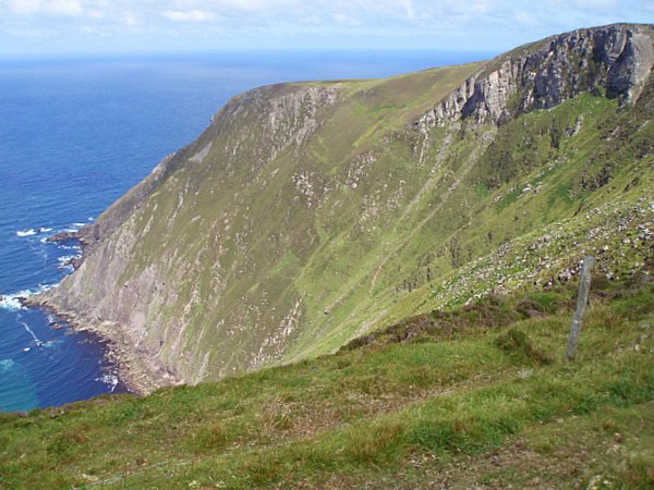
English: An Sas (Sauce Creek) The eastern side of An Sas where the cliffs reach up to 300m. A small path can just be made out coming from behind the rocky outcrop in the top right of the photograph and coming towards the photographer. There are many warnings telling people not to try to descend as it is very dangerous and there is a lot of land subsidence. |
| Date | |
| Source | From geograph.org.uk |
| Author | Sharon Loxton |
| Attribution (required by the license) | Sharon Loxton / An Sas (Sauce Creek) / |
| Object location | | View this and other nearby images on: OpenStreetMap |
|---|
_-_geograph.org.uk_-_219157.jpg¶ms=052.278600_N_-010.210000_E_globe:Earth_class:object_type:object_source:geograph-irishgrid(Q492163)_heading:22.00&language=en)
Licensing
edit_-_geograph.org.uk_-_219157.jpg&action=edit§ion=2)

|
This image was taken from the Geograph project collection. See this photograph's page on the Geograph website for the photographer's contact details. The copyright on this image is owned by Sharon Loxton and is licensed for reuse under the Creative Commons Attribution-ShareAlike 2.0 license.
|
This file is licensed under the Creative Commons Attribution-Share Alike 2.0 Generic license.
Attribution: Sharon Loxton
- You are free:
- to share – to copy, distribute and transmit the work
- to remix – to adapt the work
- Under the following conditions:
- attribution – You must give appropriate credit, provide a link to the license, and indicate if changes were made. You may do so in any reasonable manner, but not in any way that suggests the licensor endorses you or your use.
- share alike – If you remix, transform, or build upon the material, you must distribute your contributions under the same or compatible license as the original.
File history
Click on a date/time to view the file as it appeared at that time.
| Date/Time | Thumbnail | Dimensions | User | Comment | |
|---|---|---|---|---|---|
| current | 20:03, 31 January 2010 | | 600 × 450 (83 KB) | GeographBot (talk | contribs) | == {{int:filedesc}} == {{Information |description={{en|1=An Sas (Sauce Creek) The eastern side of An Sas where the cliffs reach up to 300m. A small path can just be made out coming from behind the rocky outcrop in the top right of the photograph and comi |
You cannot overwrite this file.
File usage on Commons
There are no pages that use this file.
_-_geograph.org.uk_-_219157.jpg&oldid=791296020)