File:Anatolia 1097 pt.svg

Size of this PNG preview of this SVG file: 800 × 416 pixels. Other resolutions: 320 × 166 pixels | 640 × 333 pixels | 1,024 × 533 pixels | 1,280 × 666 pixels | 2,560 × 1,332 pixels | 1,440 × 749 pixels.
Original file (SVG file, nominally 1,440 × 749 pixels, file size: 103 KB)
Captions
Captions
Add a one-line explanation of what this file represents
Summary edit
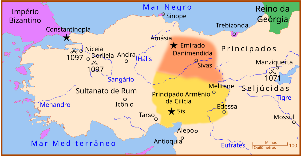
| Description |
Português: Mapa da Anatólia antes do cerco de Niceia em 1097. Há menção a batalha de Manzikert de 1071. |
| Date | |
| Source |
This file was derived from: Anatolia 1097.svg: |
| Author | MapMaster (talk · contribs) |
| Other versions |
[]
|


Licensing edit
This file is licensed under the Creative Commons Attribution 3.0 Unported license.
- You are free:
- to share – to copy, distribute and transmit the work
- to remix – to adapt the work
- Under the following conditions:
- attribution – You must give appropriate credit, provide a link to the license, and indicate if changes were made. You may do so in any reasonable manner, but not in any way that suggests the licensor endorses you or your use.
File history
Click on a date/time to view the file as it appeared at that time.
| Date/Time | Thumbnail | Dimensions | User | Comment | |
|---|---|---|---|---|---|
| current | 21:45, 7 November 2014 | | 1,440 × 749 (103 KB) | Renato de Carvalho Ferreira (talk | contribs) | ajustes na toponímia |
| 21:51, 3 September 2013 |  | 1,440 × 749 (100 KB) | Renato de Carvalho Ferreira (talk | contribs) | Corrigindo Manziquerta! Ela estava sumindo um pouco na posição anterior! | |
| 21:49, 3 September 2013 |  | 1,440 × 749 (100 KB) | Renato de Carvalho Ferreira (talk | contribs) | Tapinha | |
| 23:48, 3 May 2013 |  | 1,440 × 749 (100 KB) | Renato de Carvalho Ferreira (talk | contribs) | Correção de topônimo! | |
| 04:20, 30 March 2013 |  | 1,440 × 749 (99 KB) | Renato de Carvalho Ferreira (talk | contribs) | User created page with UploadWizard |
You cannot overwrite this file.
File usage on Commons
The following 8 pages use this file:
File usage on other wikis
The following other wikis use this file:
- Usage on en.wikipedia.org
- Usage on pt.wikipedia.org