File:Ancien magasin Morgan, 587, rue Sainte-Catherine Ouest, Montréal façade 11-d.na.civile-91-497.jpg

Size of this preview: 800 × 540 pixels. Other resolutions: 320 × 216 pixels | 640 × 432 pixels | 1,024 × 692 pixels | 1,500 × 1,013 pixels.
Original file (1,500 × 1,013 pixels, file size: 1.24 MB, MIME type: image/jpeg)
Captions
Captions
Add a one-line explanation of what this file represents
Summary
Object
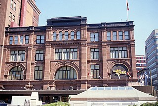
| Français : Ancien magasin Morgan, 587, rue Sainte-Catherine Ouest, Montréal : façade
( |
|||||||||||||||||||||
|---|---|---|---|---|---|---|---|---|---|---|---|---|---|---|---|---|---|---|---|---|---|
| Artist |
Hill, John Pierce, 1849-1921; |
||||||||||||||||||||
| Title |
Français : Ancien magasin Morgan, 587, rue Sainte-Catherine Ouest, Montréal : façade |
||||||||||||||||||||
| Description |
Français : Autres titres : Magasin Morgan; Henry Morgan & Co; Compagnie de la Baie d'Hudson; 587, rue Sainte-Catherine Ouest, Montréal. Description : L'entreprise fondée en 1843 par Henry Morgan devient le premier magasin à rayons de Montréal dans les années 1870. D'abord situé rue Notre-Dame puis rue McGill, ce commerce est le premier à s'installer rue Sainte-Catherine en 1890. Délaissant les quartiers anciens et les immeubles démodés, Henry Morgan fait bâtir un édifice qui possède toutes les caractéristiques des nouveaux et éclectiques « department stores » américains. Le grès rouge des façades du magasin initial est importé d'Angleterre. Agrandi successivement en 1902, 1923 et 1964, Morgan occupe tout le quadrilatère compris entre les rues Sainte-Catherine, De Maisonneuve, Union et Aylmer. La famille Morgan s'est départie de ses magasins en 1960 au profit de La Compagnie de la Baie d'Hudson. (Sources : https://www.museedelhistoire.ca/cmc/exhibitions/cpm/catalog/cat2404f.html#1226699a ; https://www.erudit.org/fr/revues/continuite/1989-n42-continuite1052773/18538ac.pdf ) |
||||||||||||||||||||
| Date | 1890 | ||||||||||||||||||||
| Medium | color photography | ||||||||||||||||||||
| Dimensions | height: 5 cm (1.9 in); width: 5 cm (1.9 in) | ||||||||||||||||||||
| Collection |
|
||||||||||||||||||||
| Current location |
|
||||||||||||||||||||
| Accession number |
11-d.na.civile-91-497 |
||||||||||||||||||||
| Notes |
Français : Image réalisée sous la direction de Luc Noppen dans le cadre des travaux du Groupe de recherche en art du Québec (GRAQ) en 1989. |
||||||||||||||||||||

Photograph
| Date | |||||||||||||||||||||||||||
| Source |
|
||||||||||||||||||||||||||
| Author | Groupe de recherche en art du Québec | ||||||||||||||||||||||||||
| Permission (Reusing this file) |
This file is licensed under the Creative Commons Attribution-Share Alike 4.0 International license.
|
||||||||||||||||||||||||||

File history
Click on a date/time to view the file as it appeared at that time.
| Date/Time | Thumbnail | Dimensions | User | Comment | |
|---|---|---|---|---|---|
| current | 12:35, 30 April 2021 | | 1,500 × 1,013 (1.24 MB) | Cephas (talk | contribs) | pattypan 20.04 |
You cannot overwrite this file.
File usage on Commons
The following page uses this file: