File:Ancona - mappa del Quartiere del Passetto.JPG
Size of this preview: 380 × 600 pixels. Other resolutions: 152 × 240 pixels | 304 × 480 pixels | 486 × 768 pixels | 649 × 1,024 pixels | 1,578 × 2,491 pixels.
Original file (1,578 × 2,491 pixels, file size: 693 KB, MIME type: image/jpeg)
Captions
Captions
Add a one-line explanation of what this file represents
Summary
edit
| Description |
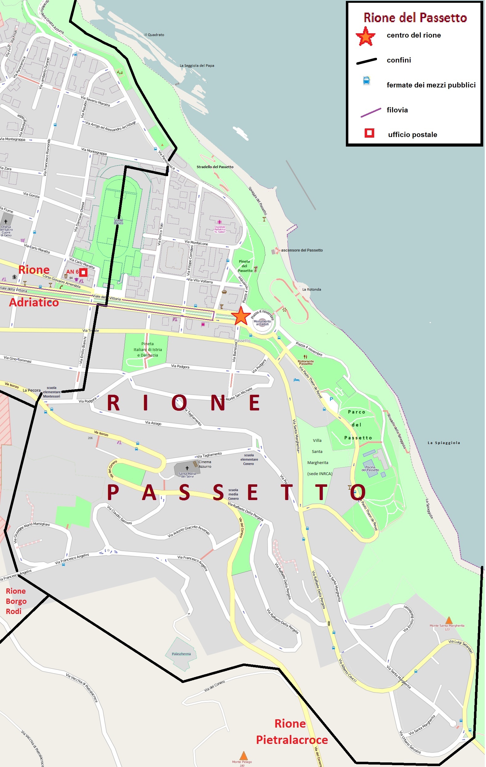
Italiano: Mappa del quartiere Passetto di Ancona, con i confini, le vie, le piazze e i parchi. |
| Date | |
| Source | Base cartografica da Openstreetmap modificata da me |
| Author | sono io l'autore |
| Permission (Reusing this file) |
libera |
Licensing
edit
This file is licensed under the Creative Commons Attribution-Share Alike 2.5 Generic license.
- You are free:
- to share – to copy, distribute and transmit the work
- to remix – to adapt the work
- Under the following conditions:
- attribution – You must give appropriate credit, provide a link to the license, and indicate if changes were made. You may do so in any reasonable manner, but not in any way that suggests the licensor endorses you or your use.
- share alike – If you remix, transform, or build upon the material, you must distribute your contributions under the same or compatible license as the original.
Original upload log
edit
The original description page was here. All following user names refer to it.wikipedia.
| Date/Time | Dimensions | User | Comment |
|---|---|---|---|
| 2015-10-14 15:41 | 1578×2491× (709995 bytes) | Gep | come modifica precedente (ci riprovo, prima era successo qualcosa) |
| 2015-10-14 15:28 | 1574×2491× (722436 bytes) | Gep | inserisco filovia, ufficio postale, scuole medie ed elementari, ascensore del Passetto e altre modifiche minori |
| 2013-02-27 19:16 | 1574×2491× (731805 bytes) | Gep | miglioramento generale |
| 2013-02-04 17:59 | 1440×1246× (662808 bytes) | Gep | Inserisco alcuni nomi di vie e di parchi che mancavano |
| 2013-02-04 17:42 | 1440×1246× (651236 bytes) | Gep | Inserisco alcuni nomi di vie che mancavano |
| 2013-02-04 15:41 | 1450×1246× (663714 bytes) | Gep | {{Informazioni file |Descrizione = Mappa del quartiere Passetto di Ancona, con i confini, le vie, le piazze e i parchi. |Fonte = Base cartografica da Openstreetmap modificata da me |Data = 4 febbraio 2013 |Autore = sono io l'autore |Licenza = libera |... |
File history
Click on a date/time to view the file as it appeared at that time.
| Date/Time | Thumbnail | Dimensions | User | Comment | |
|---|---|---|---|---|---|
| current | 14:33, 12 November 2015 | | 1,578 × 2,491 (693 KB) | Beta16 (talk | contribs) | Transferred from it.wikipedia |
You cannot overwrite this file.
File usage on Commons
There are no pages that use this file.
File usage on other wikis
The following other wikis use this file:
- Usage on it.wikipedia.org