File:Ancre Nazi (4775662887).jpg
Size of this preview: 398 × 599 pixels. Other resolutions: 159 × 240 pixels | 319 × 480 pixels | 510 × 768 pixels | 680 × 1,024 pixels | 1,360 × 2,048 pixels | 3,104 × 4,672 pixels.
Original file (3,104 × 4,672 pixels, file size: 4.36 MB, MIME type: image/jpeg)
Captions
Captions
Add a one-line explanation of what this file represents
Summary
edit.jpg&action=edit§ion=1)
| Description |
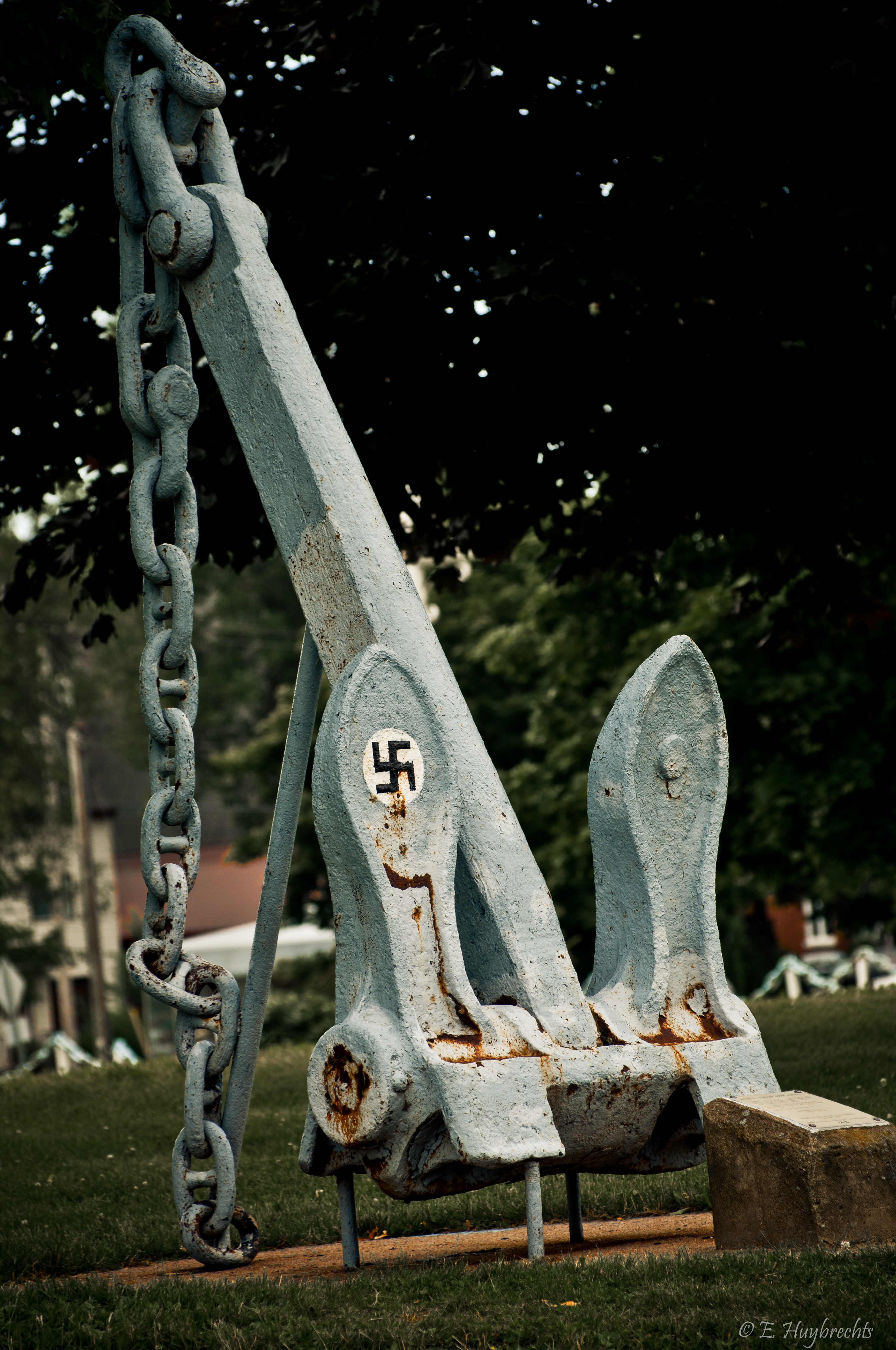
Français : Voici ce que l'écriteaux indique au sujet de cette ancre:
"Autour de la seconde guerre mondiale. Un bateau inconnu a dérivé sur le lac Saint-Louis en draguant cette ancre. Il a accroché au passage deux anciennes chaînes qui reposaient au fond avant de s'arrêter et de se perdre contre un rocher par 22m de profondeur. La seule inscription que l'on a pu identifier est une croix gammée sur l'une de ses pattes, qui nous indique le pays d'origine. Quel est le bateau qui la transportait? Dimensions: 2,3m x 1,1 m Poids: 1600 kg Trouvée en 1988 en face de Beauharnois par René Aubé"English: Here is what the sign says about this anchor: "Around the Second World War, an unknown boat drifted on Lake Saint-Louis while dredging anchor. In the process it snagged two old chains which were resting on the bottom before it stopped and was lost against a rock at a depth of 22m. The only inscription that we could identify is a swastika on one of its legs, which indicates the country of origin. Dimensions: 2.3m x 1.1m Weight: 1600 kg
Found in 1988 opposite Beauharnois by René Aubé. |
| Date | |
| Source | Ancre Nazi |
| Author | Emmanuel Huybrechts from Laval, Canada |
| Camera location | | View this and other nearby images on: OpenStreetMap |
|---|
.jpg¶ms=045.330859_N_-073.969018_E_globe:Earth_type:camera_source:Flickr_&language=en)
Licensing
edit.jpg&action=edit§ion=2)
This file is licensed under the Creative Commons Attribution 2.0 Generic license.
- You are free:
- to share – to copy, distribute and transmit the work
- to remix – to adapt the work
- Under the following conditions:
- attribution – You must give appropriate credit, provide a link to the license, and indicate if changes were made. You may do so in any reasonable manner, but not in any way that suggests the licensor endorses you or your use.
| This image, originally posted to Flickr, was reviewed on 21 February 2013 by the administrator or reviewer File Upload Bot (Magnus Manske), who confirmed that it was available on Flickr under the stated license on that date. |

|
The categories of this image need checking. You can do so here.
|
.jpg&action=edit&withJS=MediaWiki:Catcheck.js)
File history
Click on a date/time to view the file as it appeared at that time.
| Date/Time | Thumbnail | Dimensions | User | Comment | |
|---|---|---|---|---|---|
| current | 04:01, 21 February 2013 | | 3,104 × 4,672 (4.36 MB) | File Upload Bot (Magnus Manske) (talk | contribs) | Transferred from Flickr by User:russavia |
You cannot overwrite this file.
File usage on Commons
There are no pages that use this file.
.jpg&oldid=871507167)