File:Andersey LIDAR.png

Size of this preview: 800 × 446 pixels. Other resolutions: 320 × 178 pixels | 640 × 356 pixels | 1,024 × 570 pixels | 1,280 × 713 pixels | 2,528 × 1,408 pixels.
Original file (2,528 × 1,408 pixels, file size: 858 KB, MIME type: image/png)
Captions
Captions
Add a one-line explanation of what this file represents
Summary
edit
| Description |
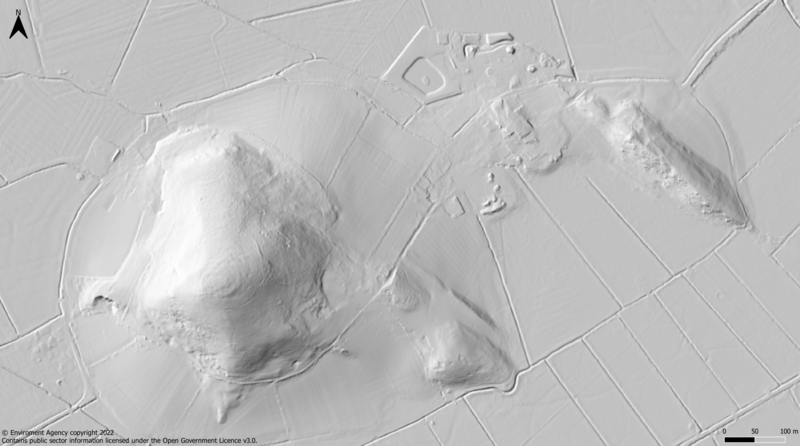
English: LIDAR hill-shade map of Andersey/Nyland Hill in Somerset.
CRS: OSGB36 British National Grid. Edited with QGIS and Paint.net from grid ST45se LIDAR composite DTM 2022 data provided by the Environment Agency National LIDAR Programme. © Environment Agency copyright and/or database right 2022. |
| Date | |
| Source | Own work |
| Author | Goldclock |
Licensing
edit
I, the copyright holder of this work, hereby publish it under the following license:
This file is licensed under the Creative Commons Attribution-Share Alike 4.0 International license.
- You are free:
- to share – to copy, distribute and transmit the work
- to remix – to adapt the work
- Under the following conditions:
- attribution – You must give appropriate credit, provide a link to the license, and indicate if changes were made. You may do so in any reasonable manner, but not in any way that suggests the licensor endorses you or your use.
- share alike – If you remix, transform, or build upon the material, you must distribute your contributions under the same or compatible license as the original.
_(St_Edwards_Crown).svg)
|
This file is licensed under the United Kingdom Open Government Licence v3.0. |
See also: Meta for information on usage on Wikimedia wikis.
|
File history
Click on a date/time to view the file as it appeared at that time.
| Date/Time | Thumbnail | Dimensions | User | Comment | |
|---|---|---|---|---|---|
| current | 00:23, 8 February 2024 | | 2,528 × 1,408 (858 KB) | Goldclock (talk | contribs) | Uploaded own work with UploadWizard |
You cannot overwrite this file.
File usage on Commons
There are no pages that use this file.