File:Andorre Topographie.png

Size of this preview: 750 × 600 pixels. Other resolutions: 300 × 240 pixels | 600 × 480 pixels | 960 × 768 pixels | 1,280 × 1,024 pixels | 1,625 × 1,300 pixels.
Original file (1,625 × 1,300 pixels, file size: 1.81 MB, MIME type: image/png)
Captions
Captions
Add a one-line explanation of what this file represents
Summary edit
| Description |
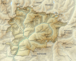
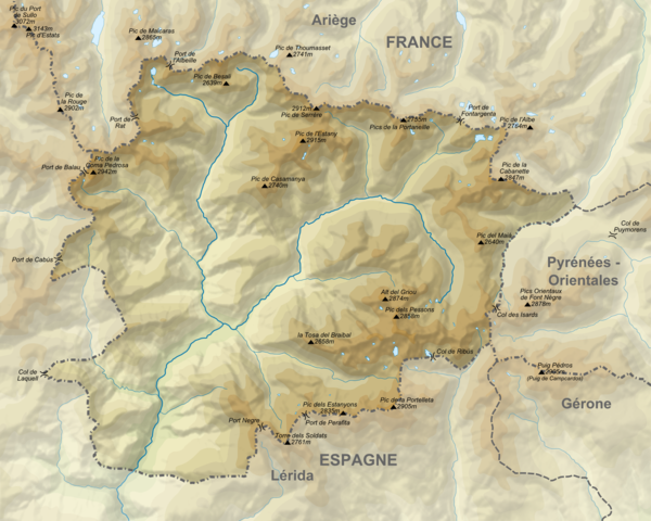
Français : Carte topographique de l'Andorre English: Topographic map of Andorra |
| Date | |
| Source |
English: Edited from Andorra_topographic_map-fr.svg
Topographic data from the NASA Shuttle Radar Topography Mission (SRTM3 v.2) (public domain) edited with 3DEM and dlgv32 Pro and vectorized with Inkscape; UTM projection; WGS84 datum; shaded relief (composite image of N-W, W and N lightning positions); Reference used for the additional data:
Approximate scale of topographic data: 1:400,000 (accuracy: about 100 m); Note : The shaded relief is a raster image embedded in the SVG file. |
| Author |
Derivative work : Austral_Lights
|
Licensing edit
This file is licensed under the Creative Commons Attribution-Share Alike 4.0 International license.
- You are free:
- to share – to copy, distribute and transmit the work
- to remix – to adapt the work
- Under the following conditions:
- attribution – You must give appropriate credit, provide a link to the license, and indicate if changes were made. You may do so in any reasonable manner, but not in any way that suggests the licensor endorses you or your use.
- share alike – If you remix, transform, or build upon the material, you must distribute your contributions under the same or compatible license as the original.
File history
Click on a date/time to view the file as it appeared at that time.
| Date/Time | Thumbnail | Dimensions | User | Comment | |
|---|---|---|---|---|---|
| current | 19:51, 22 July 2015 | | 1,625 × 1,300 (1.81 MB) | Austral Lights (talk | contribs) | User created page with UploadWizard |
You cannot overwrite this file.
File usage on Commons
The following page uses this file:
File usage on other wikis
The following other wikis use this file:
- Usage on fr.wikipedia.org
- Usage on pl.wiktionary.org
- Usage on smn.wikipedia.org
- Usage on www.wikidata.org