File:Andrea 2013-06-06 1200Z.png

Size of this preview: 800 × 450 pixels. Other resolutions: 320 × 180 pixels | 640 × 360 pixels | 1,024 × 576 pixels | 1,280 × 720 pixels | 2,048 × 1,152 pixels.
Original file (2,048 × 1,152 pixels, file size: 1.13 MB, MIME type: image/png)
Captions
Captions
Add a one-line explanation of what this file represents
Summary
edit
| Description |
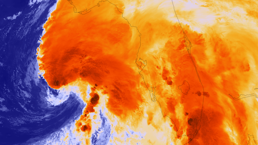
English: As Tropical Storm Andrea was intensifying over night, the Suomi NPP satellite passed over the storm, taking this highly detailed infrared imagery showing the overshooting cloud tops (colored dark orange) associated with the most intense areas of convection - and threat for tornadoes. As of 7:00 CDT on June 6th, the storm was centered 160 miles west of Tampa, FL. Sustained winds are holding at 60 mph. The National Hurricane Center and Storm Prediction Center are monitoring the storm for tornado outbreaks throughout Florida. The storm is expected to make landfall later today near Steinhatchee, FL. Up to 5 feet of storm surge expected from Apalachicola to Tampa Bay. |
| Date | |
| Source | https://www.nnvl.noaa.gov/MediaDetail2.php?MediaID=1365&MediaTypeID=1 |
| Author | NASA |
Licensing
edit
| This file is in the public domain in the United States because it was solely created by NASA. NASA copyright policy states that "NASA material is not protected by copyright unless noted". (See Template:PD-USGov, NASA copyright policy page or JPL Image Use Policy.) | ||
 |
Warnings:
|
File history
Click on a date/time to view the file as it appeared at that time.
| Date/Time | Thumbnail | Dimensions | User | Comment | |
|---|---|---|---|---|---|
| current | 02:25, 8 April 2018 | | 2,048 × 1,152 (1.13 MB) | A1Cafel (talk | contribs) | User created page with UploadWizard |
You cannot overwrite this file.
File usage on Commons
There are no pages that use this file.