File:Anenii Noi county.gif
No higher resolution available.
Anenii_Noi_county.gif (400 × 513 pixels, file size: 854 KB, MIME type: image/gif, looped, 18 frames, 2.8 s)
Captions
Captions
Add a one-line explanation of what this file represents
Summary
edit| Description |
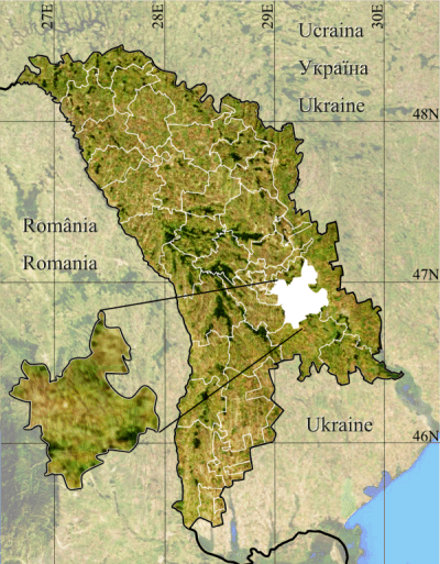
Română: Anenii Noi county.
|
| Date | |
| Source | Topographic data SRTM from NASA and World Imagery & 3DEM & Inkscape |
| Author | Asybaris01 |
| Other versions |
|


Licensing
edit
| This file is in the public domain in the United States because it was solely created by NASA. NASA copyright policy states that "NASA material is not protected by copyright unless noted". (See Template:PD-USGov, NASA copyright policy page or JPL Image Use Policy.) | ||
 |
Warnings:
|
File history
Click on a date/time to view the file as it appeared at that time.
| Date/Time | Thumbnail | Dimensions | User | Comment | |
|---|---|---|---|---|---|
| current | 20:13, 19 January 2012 | | 400 × 513 (854 KB) | Asybaris01 (talk | contribs) | {{Information |Description ={{ro|1=Anenii Noi county.}} |Source =Topographic data SRTM from NASA and World Imagery & 3DEM & Inkscape |Author =Asybaris01 |Date =jan 2012 |Permission = |other_versions = } |
You cannot overwrite this file.
File usage on Commons
The following 5 pages use this file:
File usage on other wikis
The following other wikis use this file:
- Usage on ceb.wikipedia.org
- Usage on en.wikipedia.org
- Usage on fr.wikipedia.org
- Usage on it.wikipedia.org
- Usage on ka.wikipedia.org
- Usage on nl.wikipedia.org
- Usage on no.wikipedia.org
- Usage on pl.wikipedia.org
- Usage on pt.wikipedia.org
- Usage on sk.wikipedia.org
- Usage on sv.wikipedia.org
- Usage on ur.wikipedia.org
- Usage on www.wikidata.org