File:AnglophoneWorld.svg

Size of this PNG preview of this SVG file: 800 × 411 pixels. Other resolutions: 320 × 164 pixels | 640 × 329 pixels | 1,024 × 526 pixels | 1,280 × 657 pixels | 2,560 × 1,314 pixels | 863 × 443 pixels.
Original file (SVG file, nominally 863 × 443 pixels, file size: 1.61 MB)
Captions
Captions
Add a one-line explanation of what this file represents
Summary
edit
| Description |
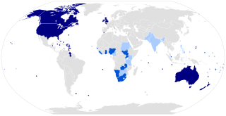
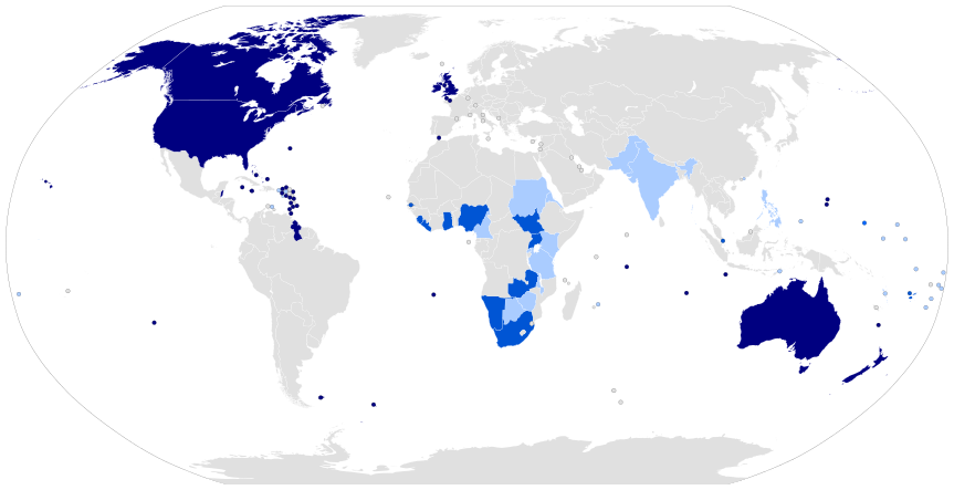
English: Dark blue: places where English is the dominant national and native language.
Medium blue: Places where English is the primary lingua franca and official language. Lightest blue: Other places where English is official. |
| Date | |
| Source |
File:BlankMap-World-Microstates.svg This W3C-unspecified vector image was created with Inkscape . |
| Author | ThisguyYEAH |
Licensing
edit
| I, the copyright holder of this work, release this work into the public domain. This applies worldwide. In some countries this may not be legally possible; if so: I grant anyone the right to use this work for any purpose, without any conditions, unless such conditions are required by law. |
| Annotations | This image is annotated: View the annotations at Commons |
File history
Click on a date/time to view the file as it appeared at that time.
| Date/Time | Thumbnail | Dimensions | User | Comment | |
|---|---|---|---|---|---|
| current | 03:11, 28 November 2013 | | 863 × 443 (1.61 MB) | MrWonderphul (talk | contribs) | Upgraded some countries to proper category. |
| 23:27, 26 November 2013 |  | 863 × 443 (1.61 MB) | ThisguyYEAH (talk | contribs) | Added Timor-Leste where it is an official working language. | |
| 23:21, 26 November 2013 |  | 863 × 443 (1.61 MB) | ThisguyYEAH (talk | contribs) | User created page with UploadWizard |
You cannot overwrite this file.
File usage on Commons
There are no pages that use this file.