File:Anguilla map.png
No higher resolution available.
Anguilla_map.png (325 × 349 pixels, file size: 6 KB, MIME type: image/png)
Captions
Captions
Add a one-line explanation of what this file represents
Summary edit
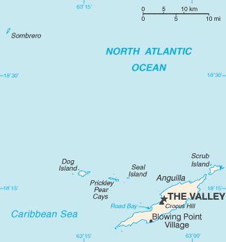
| Description |
Español: Mapa de Anguila
English: Map of British overseas territory of Anguilla, comprising main eponymous island and smaller islets and cays. |
|||
| Date | Unknown date | |||
| Source | CIA World Factbook | |||
| Author | United States Central Intelligence Agency | |||
| Permission (Reusing this file) |
|

File history
Click on a date/time to view the file as it appeared at that time.
| Date/Time | Thumbnail | Dimensions | User | Comment | |
|---|---|---|---|---|---|
| current | 22:44, 10 April 2023 | | 325 × 349 (6 KB) | Lojwe (talk | contribs) | Cropped 1 % horizontally, 1 % vertically using CropTool with precise mode. |
| 02:39, 6 June 2005 |  | 328 × 352 (15 KB) | Taichi (talk | contribs) | (Map of Anguilla. {{PD-USGov-CIA-WF}}) |
You cannot overwrite this file.
File usage on Commons
The following page uses this file:
File usage on other wikis
The following other wikis use this file:
- Usage on ba.wikipedia.org
- Usage on be.wikipedia.org
- Usage on br.wikipedia.org
- Usage on ca.wikipedia.org
- Usage on de.wikivoyage.org
- Usage on dsb.wikipedia.org
- Usage on en.wikipedia.org
- Usage on es.wikipedia.org
- Usage on eu.wikipedia.org
- Usage on fa.wikipedia.org
- Usage on fr.wikipedia.org
- Usage on fr.wiktionary.org
- Usage on he.wikipedia.org
- Usage on hr.wikipedia.org
- Usage on hu.wikipedia.org
- Usage on id.wikipedia.org
- Usage on io.wikipedia.org
- Usage on it.wikipedia.org
- Usage on ko.wikipedia.org
- Usage on nl.wikipedia.org
- Usage on nn.wikipedia.org
- Usage on pl.wikipedia.org
- Usage on ps.wikipedia.org
- Usage on pt.wikipedia.org
- Usage on ru.wikipedia.org
- Usage on sh.wikipedia.org
- Usage on sk.wikipedia.org
- Usage on sv.wikipedia.org
- Usage on sw.wikipedia.org
- Usage on th.wikipedia.org
- Usage on to.wikipedia.org
- Usage on tr.wikipedia.org
- Usage on tr.wiktionary.org
View more global usage of this file.