File:Anjouan invasion-map-fr.svg

Size of this PNG preview of this SVG file: 734 × 600 pixels. Other resolutions: 294 × 240 pixels | 588 × 480 pixels | 940 × 768 pixels | 1,254 × 1,024 pixels | 2,507 × 2,048 pixels | 841 × 687 pixels.
Original file (SVG file, nominally 841 × 687 pixels, file size: 836 KB)
Captions
Captions
Add a one-line explanation of what this file represents
| Description |
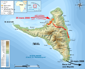
Français : Carte en français de l'invasion d'Anjouan par les forces comoriennes alliées aux forces de l'UA (Union Africaine) en 2008, avec une logistique française et lybienne. La carte montre l'évolution des combats et la fuite du Colonel Bacar. English: Map in French language showing the 2008 invasion of Anjouan Español: Mapa en francès de la invasión a Anjouan de 2008 |
| Date | (UTC) |
| Source | |
| Author |
|
| Other versions | Derivative works of this file: Anjouan invasion-map-en.svg |
| This is a retouched picture, which means that it has been digitally altered from its original version. Modifications: flèches rouges, symboles. The original can be viewed here: Anjouan topographic map-fr.svg:
|
I, the copyright holder of this work, hereby publish it under the following licenses:
This file is licensed under the Creative Commons Attribution-Share Alike 3.0 Unported, 2.5 Generic, 2.0 Generic and 1.0 Generic license.
- You are free:
- to share – to copy, distribute and transmit the work
- to remix – to adapt the work
- Under the following conditions:
- attribution – You must give appropriate credit, provide a link to the license, and indicate if changes were made. You may do so in any reasonable manner, but not in any way that suggests the licensor endorses you or your use.
- share alike – If you remix, transform, or build upon the material, you must distribute your contributions under the same or compatible license as the original.

|
Permission is granted to copy, distribute and/or modify this document under the terms of the GNU Free Documentation License, Version 1.2 or any later version published by the Free Software Foundation; with no Invariant Sections, no Front-Cover Texts, and no Back-Cover Texts. A copy of the license is included in the section entitled GNU Free Documentation License. |
You may select the license of your choice.
Original upload log edit
This image is a derivative work of the following images:
- File:Anjouan_topographic_map-fr.svg licensed with Cc-by-sa-3.0,2.5,2.0,1.0, GFDL
- 2011-03-13T20:31:42Z Bourrichon 841x687 (781398 Bytes) '
- 2011-03-13T15:40:15Z Bourrichon 841x687 (781390 Bytes) {{Location|12|13|30|S|44|22|30|E|scale:500000}} {{Information |Description= {{fr|Carte topographique en français d'[[:fr:Anjouan|]]}}{{de|Topographische Karte zum [[:de:Anjouan|]], in Französische}}{{en|Topographic map in F
Uploaded with derivativeFX
File history
Click on a date/time to view the file as it appeared at that time.
| Date/Time | Thumbnail | Dimensions | User | Comment | |
|---|---|---|---|---|---|
| current | 20:09, 14 March 2011 | | 841 × 687 (836 KB) | Bourrichon (talk | contribs) | corr typo |
| 19:37, 14 March 2011 |  | 841 × 687 (819 KB) | Bourrichon (talk | contribs) | bug | |
| 19:35, 14 March 2011 |  | 841 × 687 (819 KB) | Bourrichon (talk | contribs) | corr bug | |
| 19:09, 14 March 2011 |  | 841 × 687 (795 KB) | Bourrichon (talk | contribs) | {{Information |Description={{fr|Carte en français de l'invasion d'Anjouan par les forces comoriennes alliées aux forces de l'UA (Union Africaine) en 2008, avec une logistique française et lybienne. La carte montre l'� |
You cannot overwrite this file.
File usage on Commons
The following page uses this file:
File usage on other wikis
The following other wikis use this file:
- Usage on fr.wikipedia.org