File:Anniston Alabama map 1887.png
(Redirected from File:Anniston Alabama map 1887.gif)
No higher resolution available.
Anniston_Alabama_map_1887.png (482 × 336 pixels, file size: 148 KB, MIME type: image/png)
Captions
Captions
Add a one-line explanation of what this file represents
Summary
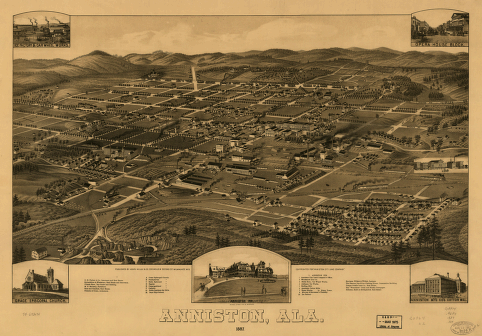
edit| Description | Anniston, Ala. 1887 | ||
| Date | |||
| Source | LOC | ||
| Author | Beck & Pauli Lith. Co. "Copyrighted for 'Anniston City Land Company'." | ||
| Other versions |
|

Licensing
edit
This work is in the public domain in the United States because it was published (or registered with the U.S. Copyright Office) before January 1, 1929.
Public domain works must be out of copyright in both the United States and in the source country of the work in order to be hosted on the Commons. If the work is not a U.S. work, the file must have an additional copyright tag indicating the copyright status in the source country.
Note: This tag should not be used for sound recordings. |
Notes
edit
- Perspective map not drawn to scale.
- Bird's-eye-view.
- "Copyrighted for 'Anniston City Land Company'."
- Reference: LC Panoramic maps (2nd ed.), 1
- Includes illus. and index to points of interest.
Medium
edit
- col. map 34 x 62 cm.
Repository
edit
- Library of Congress Geography and Map Division Washington, D.C. 20540-4650 USA

|
This map is available from the United States Library of Congress's Geography & Map Division
under the digital ID g3974a.pm000010. This tag does not indicate the copyright status of the attached work. A normal copyright tag is still required. See Commons:Licensing.
|
Original upload log
edit
| Date/Time | Dimensions | User | Comment |
|---|---|---|---|
| 10 May 2008, 05:33:12 | 482 × 336 (131112 bytes) | Spyder Monkey (talk · contribs) | == Summary == {{Information |Description=Anniston, Ala. 1887 |Source=LOC |Date=1887 |Author=Beck & Pauli Lith. Co. "Copyrighted for 'Anniston City Land Company'." |Permission=see below |other_versions= }} == Licensing: == {{PD-US}} ==Notes== *Perspectiv |
File history
Click on a date/time to view the file as it appeared at that time.
| Date/Time | Thumbnail | Dimensions | User | Comment | |
|---|---|---|---|---|---|
| current | 21:59, 16 August 2014 | | 482 × 336 (148 KB) | GifTagger (talk | contribs) | Bot: Converting file to superior PNG file. (Source: Anniston_Alabama_map_1887.gif). This GIF was problematic due to non-greyscale color table. |
You cannot overwrite this file.
File usage on Commons
The following page uses this file:
- File:Anniston Alabama map 1887.gif (file redirect)
File usage on other wikis
The following other wikis use this file:
- Usage on en.wikipedia.org