File:Antarctic expedition map (Amundsen - Scott)-bg.svg

Size of this PNG preview of this SVG file: 610 × 599 pixels. Other resolutions: 244 × 240 pixels | 489 × 480 pixels | 782 × 768 pixels | 1,042 × 1,024 pixels | 2,084 × 2,048 pixels | 1,898 × 1,865 pixels.
Original file (SVG file, nominally 1,898 × 1,865 pixels, file size: 434 KB)
Captions
Captions
Add a one-line explanation of what this file represents
| Description |
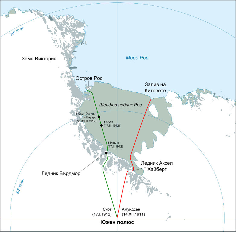
English: Map showing the polar journeys of the Scott's Terra Nova expedition (green) and Amundsen's expedition (red) to reach the South Pole Français : Carte montrant les parcours de l'expédition Terra Nova de Scott (vert) et celle d'Amundsen (rouge) pour atteindre le Pôle Sud Български: Карта на пътя на експедициите на Руал Амундсен (в червено) и Робърт Скот (в зелено) към Южния полюс |
| Date | (UTC) |
| Source | |
| Author |
|
| Other versions |
[]
|
-ar.svg)
-bg.svg)
-ca.svg)
-cs.svg)
-cs-colorswap.svg)
-de.svg)
-el.svg)
-en.svg)
-es.svg)
-fr.svg)
-ka.svg)
-no.svg)
-ru.svg)
-he.svg)
-zh-hans.svg)
-zh-hant.svg)
| This is a retouched picture, which means that it has been digitally altered from its original version. Modifications: translated to Bulgarian. The original can be viewed here: Antarctic expedition map (Amundsen - Scott)-en.svg:
|
This file is licensed under the Creative Commons Attribution-Share Alike 3.0 Unported license.
- You are free:
- to share – to copy, distribute and transmit the work
- to remix – to adapt the work
- Under the following conditions:
- attribution – You must give appropriate credit, provide a link to the license, and indicate if changes were made. You may do so in any reasonable manner, but not in any way that suggests the licensor endorses you or your use.
- share alike – If you remix, transform, or build upon the material, you must distribute your contributions under the same or compatible license as the original.
Original upload log
edit-bg.svg&action=edit§ion=1)
This image is a derivative work of the following images:
- File:Antarctic_expedition_map_(Amundsen_-_Scott)-en.svg licensed with PD-self
- 2010-03-06T21:15:32Z S.L. 1898x1865 (313729 Bytes) revert
- 2010-03-06T21:13:21Z S.L. 400x512 (2930279 Bytes) better version, mistakes fixed
- 2008-03-17T18:44:15Z Shakki 1898x1865 (313729 Bytes) {{Information |Description={{en|Map showing the polar journeys of the Scott's ''Terra Nova'' expedition (green) and Amundsen's expedition (red) to reach the South Pole}} {{fr|Carte montrant les parcours de l'expédition ''Ter
Uploaded with derivativeFX
W3C-validity not checked.
File history
Click on a date/time to view the file as it appeared at that time.
| Date/Time | Thumbnail | Dimensions | User | Comment | |
|---|---|---|---|---|---|
| current | 20:11, 21 August 2010 | | 1,898 × 1,865 (434 KB) | Iliev (talk | contribs) | Corrected a small typo. Thanks to bg:User:Spiritia for pointing that out. |
| 20:00, 21 August 2010 |  | 1,898 × 1,865 (434 KB) | Iliev (talk | contribs) | Corrected the name of Ross Ice Shelf („Ледено поле Рос“ → „Шелфов ледник Рос“). Thanks to bg:User:Apcbg for pointing that out. | |
| 21:30, 10 August 2010 |  | 1,898 × 1,865 (432 KB) | Iliev (talk | contribs) | Text converted to paths in order to avoid possible garbling. Some text also enlarged slightly to increase legibility. | |
| 21:25, 10 August 2010 |  | 1,898 × 1,865 (295 KB) | Iliev (talk | contribs) | {{Information |Description={{en|Map showing the polar journeys of the Scott's ''Terra Nova'' expedition (green) and Amundsen's expedition (red) to reach the South Pole}} {{fr|Carte montrant les parcours de l'expédition ''Terra Nova'' de Scott (vert) et c |
You cannot overwrite this file.
File usage on Commons
The following 17 pages use this file:
- File:Antarctic expedition map (Amundsen - Scott)-ar.svg
- File:Antarctic expedition map (Amundsen - Scott)-bg.svg
- File:Antarctic expedition map (Amundsen - Scott)-ca.svg
- File:Antarctic expedition map (Amundsen - Scott)-cs-colorswap.svg
- File:Antarctic expedition map (Amundsen - Scott)-cs.svg
- File:Antarctic expedition map (Amundsen - Scott)-de.svg
- File:Antarctic expedition map (Amundsen - Scott)-el.svg
- File:Antarctic expedition map (Amundsen - Scott)-en.svg
- File:Antarctic expedition map (Amundsen - Scott)-es.svg
- File:Antarctic expedition map (Amundsen - Scott)-fr.svg
- File:Antarctic expedition map (Amundsen - Scott)-he.svg
- File:Antarctic expedition map (Amundsen - Scott)-ka.svg
- File:Antarctic expedition map (Amundsen - Scott)-no.svg
- File:Antarctic expedition map (Amundsen - Scott)-ru.svg
- File:Antarctic expedition map (Amundsen - Scott)-zh-hans.svg
- File:Antarctic expedition map (Amundsen - Scott)-zh-hant.svg
- Template:Other versions/Antarctic expedition map (Amundsen - Scott)
File usage on other wikis
The following other wikis use this file:
- Usage on bg.wikipedia.org
-bg.svg&oldid=798905238)