File:Aoraki Mount Cook National Park and the Southern Alps (MODIS 2019-05-19).jpg

Original file (1,852 × 1,571 pixels, file size: 1.14 MB, MIME type: image/jpeg)
Captions
Captions
Summary
edit.jpg&action=edit§ion=1)
| Description |
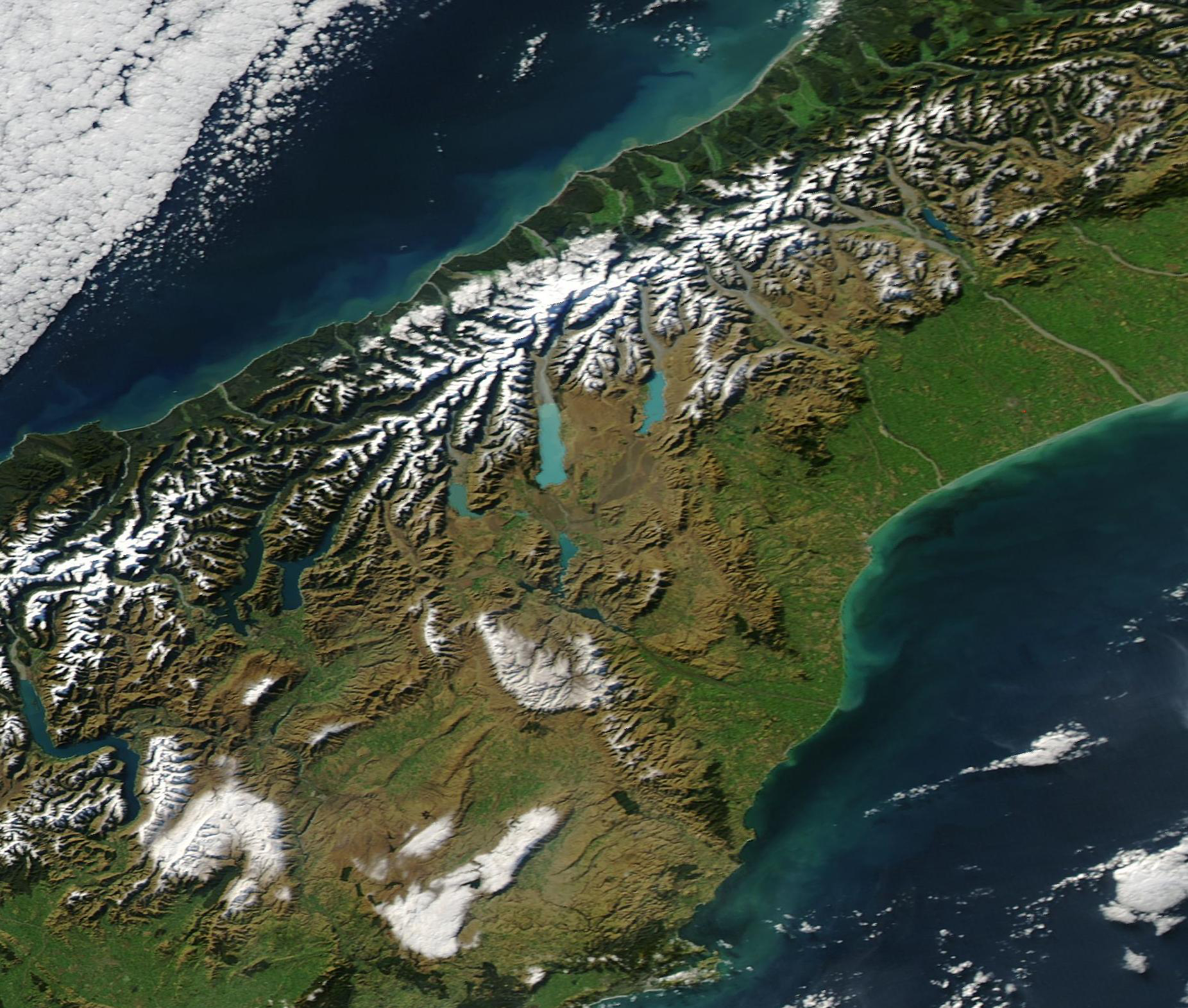
English: Aoraki Mount Cook National Park has been described as a rugged land of ice and rock, with skyscraping peaks, glaciers and permanent snow fields, all set under a star-studded sky. The park, which sits in the Southern Alps, encompasses 23 peaks over 3,000 meters (9,842.52 feet), including New Zealand’s highest Mountain, Aoraki/Mount Cook. The park’s largest glacier, the Tasman Glacier, extends about 27 km (16.8 mi) long and is at least 600 meters (1,968.5 feet) thick. As the massive glacier slowly carves a deep valley, it also forms a stunning, milky-blue terminal lake. Lake Pukaki, as Tasman Glacier’s lake is known, can be seen as the largest brightly colored lake in the tall mountains of the park.
The rugged Southern Alps extend some 650 kilometers (400 miles) along the western side of New Zealand's South Island. The mountains are often obscured by clouds, which is probably why the Maoris called New Zealand "Aotearoa", the long white cloud. The higher peaks are snow-covered all year round. Westerly winds bring clouds that drop over 500 centimeters (195 inches) of rain annually on luxuriant rain forest along the west coast. The drier eastern seaboard is home to the majority of the island's population. On May 17, 2019, the Moderate Resolution Imaging Spectroradiometer (MODIS) on board NASA’s Aqua satellite acquired a true-color image of New Zealand’s South Island which highlighted Aoraki Mount Cook National Park and the Southern Alps. |
||
| Date | Taken on 17 May 2019 | ||
| Source |
Aoraki Mount Cook National Park and the Southern Alps (direct link)
|
||
| Author | MODIS Land Rapid Response Team, NASA GSFC |
| This media is a product of the Aqua mission Credit and attribution belongs to the mission team, if not already specified in the "author" row |
Licensing
edit.jpg&action=edit§ion=2)
| This file is in the public domain in the United States because it was solely created by NASA. NASA copyright policy states that "NASA material is not protected by copyright unless noted". (See Template:PD-USGov, NASA copyright policy page or JPL Image Use Policy.) | ||
 |
Warnings:
|
File history
Click on a date/time to view the file as it appeared at that time.
| Date/Time | Thumbnail | Dimensions | User | Comment | |
|---|---|---|---|---|---|
| current | 03:20, 17 February 2024 | | 1,852 × 1,571 (1.14 MB) | OptimusPrimeBot (talk | contribs) | #Spacemedia - Upload of http://modis.gsfc.nasa.gov/gallery/images/image05192019_250m.jpg via Commons:Spacemedia |
You cannot overwrite this file.
File usage on Commons
There are no pages that use this file.
.jpg&oldid=873062746)