File:Apurimacrivermap.png

Size of this preview: 600 × 600 pixels. Other resolutions: 240 × 240 pixels | 480 × 480 pixels | 1,000 × 1,000 pixels.
Original file (1,000 × 1,000 pixels, file size: 450 KB, MIME type: image/png)
Captions
Captions
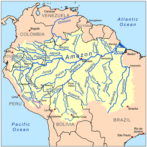
AMAZON RIVER DRAINAGE BASIN
| Description | This is a map of the Amazon River drainage basin, with the Apurimac River highlighted. |
| Date | (UTC) |
| Source | |
| Author |
|
| This is a retouched picture, which means that it has been digitally altered from its original version. Modifications: highlight of the Apurimac River and size reduction. The original can be viewed here: Amazonriverbasin basemap.png:
|
I, the copyright holder of this work, hereby publish it under the following license:
This file is licensed under the Creative Commons Attribution-Share Alike 3.0 Unported license.
- You are free:
- to share – to copy, distribute and transmit the work
- to remix – to adapt the work
- Under the following conditions:
- attribution – You must give appropriate credit, provide a link to the license, and indicate if changes were made. You may do so in any reasonable manner, but not in any way that suggests the licensor endorses you or your use.
- share alike – If you remix, transform, or build upon the material, you must distribute your contributions under the same or compatible license as the original.
Original upload log
edit
This image is a derivative work of the following images:
- File:Amazonriverbasin_basemap.png licensed with Cc-by-sa-3.0
- 2008-09-08T17:13:04Z Kmusser 1500x1500 (921325 Bytes) {{Information |Description=This is a map of the [[:en:Amazon River|Amazon River]] drainage basin. |Source=Own work using [[http://www.maproom.psu.edu/dcw/ Digital Chart of the World]] and [[http://edc.usgs.gov/products/elevat
Uploaded with derivativeFX
File history
Click on a date/time to view the file as it appeared at that time.
| Date/Time | Thumbnail | Dimensions | User | Comment | |
|---|---|---|---|---|---|
| current | 12:37, 31 October 2009 | | 1,000 × 1,000 (450 KB) | Kojaman (talk | contribs) | {{Information |Description=This is a map of the Amazon River drainage basin, with a marc of the Apurimac River. |Source=*File:Amazonriverbasin_basemap.png |Date=2009-10-31 12:34 (UTC) |Author=*[[:File:Amazonriverbasin_basemap.pn |
You cannot overwrite this file.
File usage on Commons
There are no pages that use this file.
File usage on other wikis
The following other wikis use this file:
- Usage on ast.wikipedia.org
- Usage on bg.wikipedia.org
- Usage on en.wikipedia.org
- Usage on es.wikipedia.org
- Usage on fa.wikipedia.org
- Usage on he.wikipedia.org
- Usage on hu.wikipedia.org
- Usage on hy.wikipedia.org
- Usage on ml.wikipedia.org
- Usage on nl.wikipedia.org
- Usage on qu.wikipedia.org
- Usage on te.wikipedia.org