File:Aragonese Empire 1443.svg

Size of this PNG preview of this SVG file: 386 × 255 pixels. Other resolutions: 320 × 211 pixels | 640 × 423 pixels | 1,024 × 676 pixels | 1,280 × 846 pixels | 2,560 × 1,691 pixels.
Original file (SVG file, nominally 386 × 255 pixels, file size: 98 KB)
Captions
Captions
Add a one-line explanation of what this file represents
Summary edit
| Description |
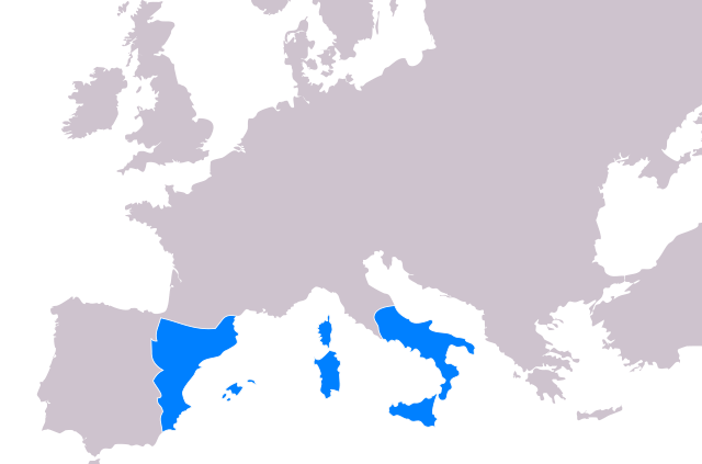
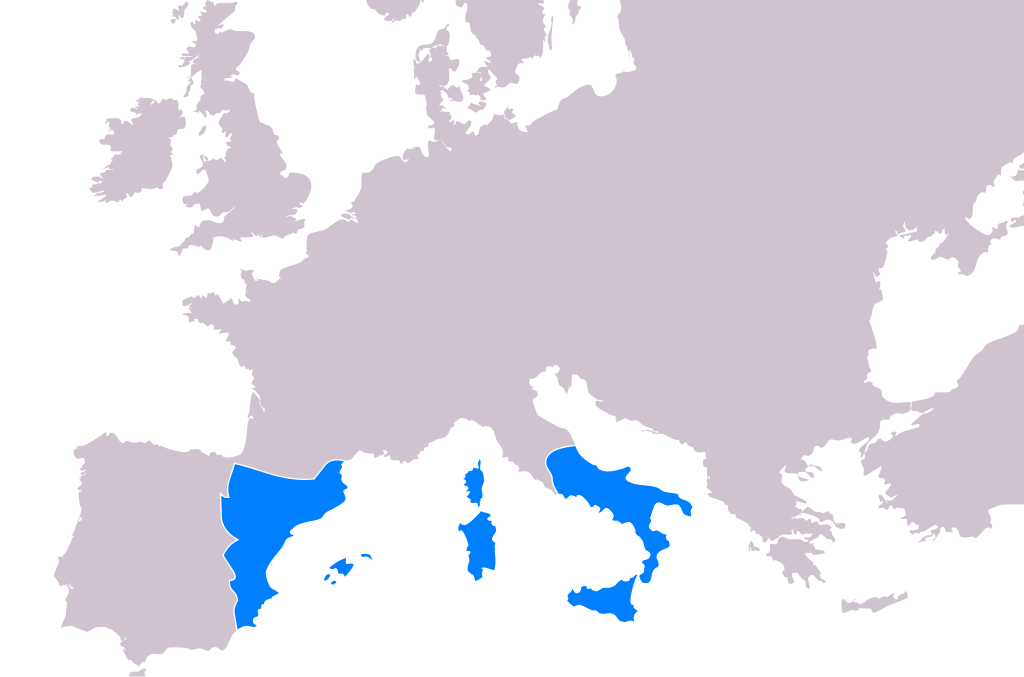
Català: Imperi de la Corona d'Aragó el 1443
Português: O Império da Coroa de Aragão em 1443 |
| Date | (UTC) |
| Source | |
| Author |
|
I, the copyright holder of this work, hereby publish it under the following license:
| I, the copyright holder of this work, release this work into the public domain. This applies worldwide. In some countries this may not be legally possible; if so: I grant anyone the right to use this work for any purpose, without any conditions, unless such conditions are required by law. |
Original upload log edit
This image is a derivative work of the following images:
- File:Blank_map_europe_no_borders.svg licensed with PD-self
- 2009-01-28T19:52:57Z Phirosiberia 10495x7945 (309630 Bytes) Only one object.
- 2009-01-22T00:17:50Z Cthuljew 680x520 (323707 Bytes) {{Information |Description=* Description: Blank map of Europe * Source: Modification of SVG trace of [[:Image:Blank map europe.png|PNG]] of the same name. Original PNG based on CIA map [https://www.cia.gov/cia/publications/fa
Uploaded with derivativeFX
File history
Click on a date/time to view the file as it appeared at that time.
| Date/Time | Thumbnail | Dimensions | User | Comment | |
|---|---|---|---|---|---|
| current | 17:42, 28 August 2017 | | 386 × 255 (98 KB) | Cplakidas (talk | contribs) | All Catalan possessions in Greece were lost by 1390, and the dots in Anatolia and elsewhere are completely fictitious |
| 22:25, 27 July 2013 |  | 386 × 255 (102 KB) | Enok (talk | contribs) | Reverted to version as of 20:40, 24 February 2010 - Rome was never part of the Aragonese Crown. | |
| 13:17, 29 August 2012 |  | 386 × 255 (103 KB) | Phso2 (talk | contribs) | Territories lost long ago | |
| 20:48, 26 February 2010 |  | 386 × 255 (104 KB) | Beao (talk | contribs) | Tweak. | |
| 20:46, 26 February 2010 |  | 386 × 255 (104 KB) | Beao (talk | contribs) | Tweak. | |
| 20:40, 24 February 2010 |  | 386 × 255 (102 KB) | Beao (talk | contribs) | {{Information |Description=Crown of Aragonese Empire in year 1443 |Source=*File:Blank_map_europe_no_borders.svg |Date=2010-02-24 20:39 (UTC) |Author=*File:Blank_map_europe_no_borders.svg: derivative work: cthu |
You cannot overwrite this file.
File usage on Commons
The following page uses this file:
File usage on other wikis
The following other wikis use this file:
- Usage on an.wikipedia.org
- Usage on ast.wikipedia.org
- Usage on be.wikipedia.org
- Usage on bg.wikipedia.org
- Usage on br.wikipedia.org
- Usage on ca.wikipedia.org
- Usage on ceb.wikipedia.org
- Usage on cs.wikipedia.org
- Usage on el.wikipedia.org
- Usage on en.wikipedia.org
- Usage on es.wikipedia.org
- Usage on fr.wikipedia.org
- Usage on gl.wikipedia.org
- Usage on hy.wikipedia.org
- Usage on incubator.wikimedia.org
- Usage on io.wikipedia.org
- Usage on ja.wikipedia.org
- Usage on la.wikipedia.org
- Usage on li.wikipedia.org
- Usage on simple.wikipedia.org
- Usage on sk.wikipedia.org
- Usage on sr.wikipedia.org
- Usage on sv.wikipedia.org
- Usage on uk.wikipedia.org
- Usage on ur.wikipedia.org
- Usage on zh.wikipedia.org