File:Areál cisterciáckého kláštera v Plasích.jpg

Size of this preview: 800 × 534 pixels. Other resolutions: 320 × 213 pixels | 640 × 427 pixels | 1,024 × 683 pixels | 1,280 × 854 pixels | 1,600 × 1,067 pixels.
Original file (1,600 × 1,067 pixels, file size: 482 KB, MIME type: image/jpeg)
Captions
Captions
Add a one-line explanation of what this file represents
| Description |
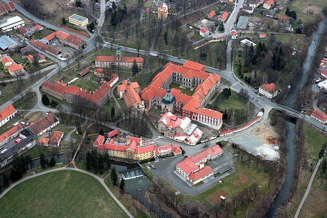
Čeština: Areál cisterciáckého kláštera v Plasích. V levém dolním rohu je východní konec Velké louky, mezi řekou Střelou a dnešní silnicí 27 se nachází zleva hospodářský dvůr, prelatura, za ní sýpky s gotickou Královskou kaplí, dále kostel Nanebevzetí Panny Marie přiléhající k mohutné budově konventu s kaplí sv. Benedikta. V pozadí je vidět kostel sv. Václava. |
| Date | |
| Source |
Čeština: poskytnutá digitální fotografie |
| Author | Ivo Lukačovič |
| Permission (Reusing this file) |
author's explicit permission to publish his photos on Wikipedia under CC license This file is licensed under the Creative Commons Attribution-Share Alike 2.5 Generic license.
|
File history
Click on a date/time to view the file as it appeared at that time.
| Date/Time | Thumbnail | Dimensions | User | Comment | |
|---|---|---|---|---|---|
| current | 19:16, 29 May 2007 | | 1,600 × 1,067 (482 KB) | Adam Hauner (talk | contribs) | {{Information |Description={{cs|Areál cisterciáckého kláštera v Plasích. V levém dolním rohu je východní konec Velké louky, mezi řekou Střelou a dnešní [[:cs:Silnice I/27|silnic� |
You cannot overwrite this file.
File usage on Commons
The following 3 pages use this file:
File usage on other wikis
The following other wikis use this file:
- Usage on cs.wikipedia.org
- Usage on de.wikipedia.org
- Usage on en.wikipedia.org
- Usage on es.wikipedia.org
- Usage on id.wikipedia.org
- Usage on it.wikipedia.org
- Usage on ro.wikipedia.org
- Usage on sl.wikipedia.org
- Usage on uk.wikipedia.org
- Usage on www.wikidata.org