File:Arlington map.png
Size of this preview: 610 × 599 pixels. Other resolutions: 244 × 240 pixels | 488 × 480 pixels | 782 × 768 pixels | 1,042 × 1,024 pixels | 1,500 × 1,474 pixels.
Original file (1,500 × 1,474 pixels, file size: 2.46 MB, MIME type: image/png)
Captions
Captions
Add a one-line explanation of what this file represents
Summary
edit
| Description |
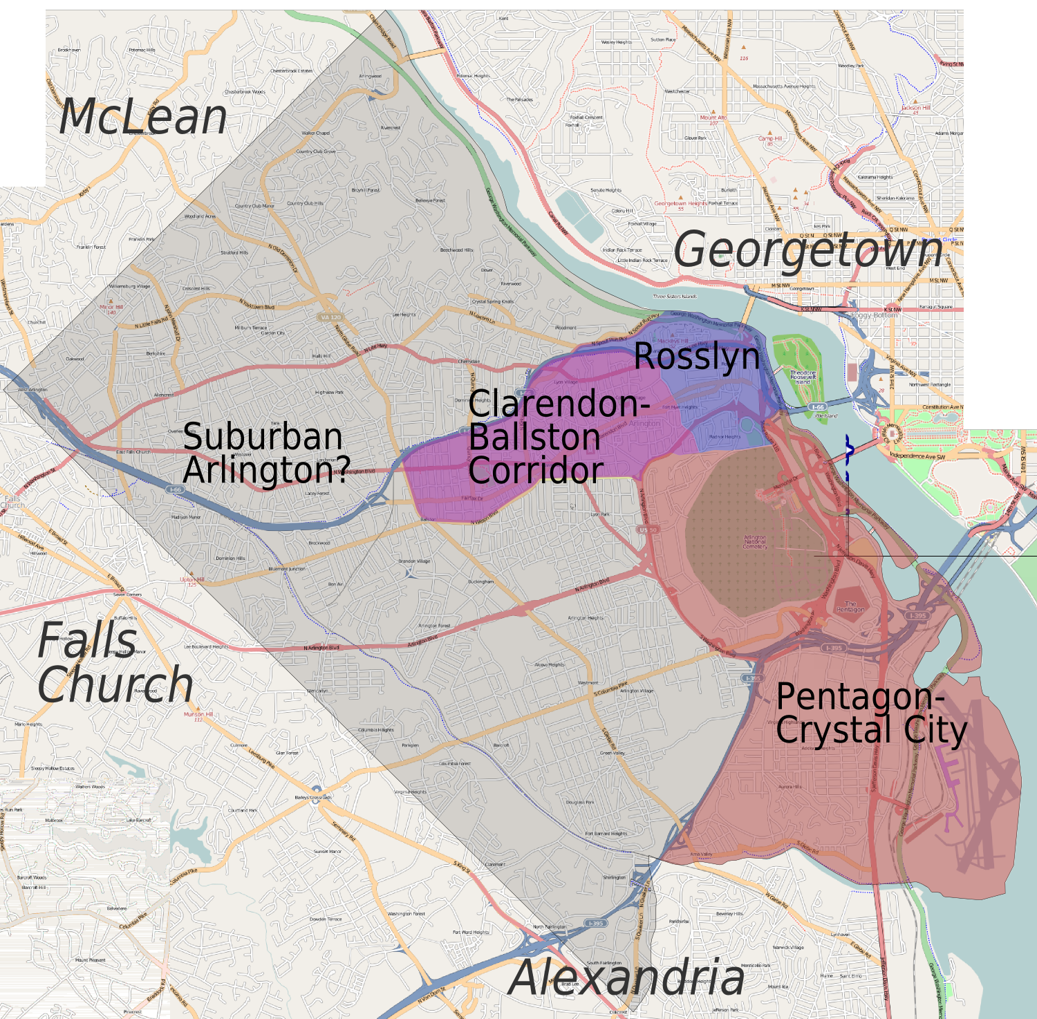
English: Arlington (Virginia) regions/cities map. Draft version for discussion |
| Date | |
| Source |
This file was derived from: Arlington map.svg |
| Author | Peter Fitzgerald, OpenStreetMap [1] |

|
File:Arlington map.svg is a vector version of this file. It should be used in place of this PNG file when not inferior.
File:Arlington map.png → File:Arlington map.svg
For more information, see Help:SVG. |
 |
Licensing
edit
This file is licensed under the Creative Commons Attribution-Share Alike 2.0 Generic license.
- You are free:
- to share – to copy, distribute and transmit the work
- to remix – to adapt the work
- Under the following conditions:
- attribution – You must give appropriate credit, provide a link to the license, and indicate if changes were made. You may do so in any reasonable manner, but not in any way that suggests the licensor endorses you or your use.
- share alike – If you remix, transform, or build upon the material, you must distribute your contributions under the same or compatible license as the original.
Original upload log
edit
| This file was imported from Wikivoyage WTS. |
The original description page was here. All following user names refer to wts.wikivoyage-old.
- 2009-04-01 03:06 (WT-shared) Peterfitzgerald archive copy at the Wayback Machine 1500×1474 (2576713 bytes) {{Imagecredit|credit=Peter Fitzgerald, OpenStreetMap [http://openstreetmap.org]|captureDate=31 March 2009|location=Arlington|source=[[:Image (Import from wikitravel.org/shared)
- 2009-10-07 19:56 (WT-shared) Peterfitzgerald archive copy at the Wayback Machine 1709×3008 (1924596 bytes) == Summary == {{Imagecredit|credit=Peter Fitzgerald|captureDate=7 October 2009|location=Arlington (Virginia)|source=[[:Image:DC_map_suburbs. (Import from wikitravel.org/shared)
- 2009-10-07 20:09 (WT-shared) Peterfitzgerald archive copy at the Wayback Machine 1500×1474 (2576713 bytes) ack! Reverted to version as of 03:06, 1 April 2009 (Import from wikitravel.org/shared)
File history
Click on a date/time to view the file as it appeared at that time.
| Date/Time | Thumbnail | Dimensions | User | Comment | |
|---|---|---|---|---|---|
| current | 04:01, 21 November 2012 | | 1,500 × 1,474 (2.46 MB) | OgreBot (talk | contribs) | (BOT): Reverting to most recent version before archival |
| 04:01, 21 November 2012 |  | 1,709 × 3,008 (1.84 MB) | OgreBot (talk | contribs) | (BOT): Uploading old version of file from wts.wikivoyage; originally uploaded on 2009-10-07 19:56:14 by (WT-shared) Peterfitzgerald | |
| 21:50, 17 November 2012 |  | 1,500 × 1,474 (2.46 MB) | MGA73bot2 (talk | contribs) | {{BotMoveToCommons|wts.oldwikivoyage|year={{subst:CURRENTYEAR}}|month={{subst:CURRENTMONTHNAME}}|day={{subst:CURRENTDAY}}}} == {{int:filedesc}} == {{Information |description=Arlington regions/cities) map. Draft version for discussion, Arlington (Virgin... |
You cannot overwrite this file.
File usage on Commons
There are no pages that use this file.
File usage on other wikis
The following other wikis use this file:
- Usage on en.wikivoyage.org
- Usage on it.wikipedia.org