File:Arnhem land locator.png

Size of this preview: 282 × 600 pixels. Other resolutions: 113 × 240 pixels | 489 × 1,040 pixels.
Original file (489 × 1,040 pixels, file size: 227 KB, MIME type: image/png)
Captions
Captions
Add a one-line explanation of what this file represents

|
This locator map image could be re-created using vector graphics as an SVG file. This has several advantages; see Commons:Media for cleanup for more information. If an SVG form of this image is available, please upload it and afterwards replace this template with
{{vector version available|new image name}}.
It is recommended to name the SVG file “Arnhem land locator.svg”—then the template Vector version available (or Vva) does not need the new image name parameter. |
Summary edit
| Description |
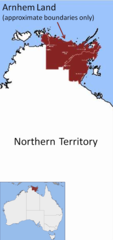
English: Location map showing approximate boundaries of Arnhem Land, Northern Territory, Australia |
| Date | |
| Source | Own work |
| Author | Glen Dillon |
Note: boundaries are approximate only. Also - Groote Eylandt and Goulburn Island are also part of Arnhem Land.
Licensing edit
| I, the copyright holder of this work, release this work into the public domain. This applies worldwide. In some countries this may not be legally possible; if so: I grant anyone the right to use this work for any purpose, without any conditions, unless such conditions are required by law. |
File history
Click on a date/time to view the file as it appeared at that time.
| Date/Time | Thumbnail | Dimensions | User | Comment | |
|---|---|---|---|---|---|
| current | 05:10, 9 September 2008 | | 489 × 1,040 (227 KB) | Glen Dillon (talk | contribs) | {{Information |Description={{en|1=Location map showing approximate boundaries of Anrhem Land, Northern Territory, Australia}} |Source=Own work by uploader |Author=Glen Dillon |Date=9 September 2008 |Permission=see below |other_version |
You cannot overwrite this file.
File usage on Commons
There are no pages that use this file.
File usage on other wikis
The following other wikis use this file:
- Usage on ar.wikipedia.org
- Usage on en.wikipedia.org
- Usage on et.wikipedia.org
- Usage on pfl.wikipedia.org
- Usage on pt.wikipedia.org
- Usage on simple.wikipedia.org