File:Arrondissement de Toul.PNG

Size of this preview: 750 × 600 pixels. Other resolutions: 300 × 240 pixels | 600 × 480 pixels | 850 × 680 pixels.
Original file (850 × 680 pixels, file size: 11 KB, MIME type: image/png)
Captions
Captions
Add a one-line explanation of what this file represents
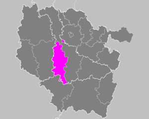
| Description | Maps of arrondissements and cantons of France: Arrondissement de Toul.PNG | ||
| Date | |||
| Source | Own work | ||
| Author | M.Minderhoud | ||
| Permission (Reusing this file) |
|
File history
Click on a date/time to view the file as it appeared at that time.
| Date/Time | Thumbnail | Dimensions | User | Comment | |
|---|---|---|---|---|---|
| current | 23:30, 15 February 2010 | | 850 × 680 (11 KB) | Entlinkt (talk | contribs) | Exclave fixed, cf. http://www.insee.fr/fr/methodes/nomenclatures/cog/carte_comcan.asp?codecan=5426 |
| 17:41, 21 November 2006 |  | 850 × 680 (31 KB) | Michiel1972 (talk | contribs) | {{Information |Description= Maps of arrondissements and cantons of France: {{subst:PAGENAME}} |Source= |Date=november 2006 |Author= M.Minderhoud |Permission= {{PD-self}} |other_versions= }} [[Category:Maps of arrondisseme |
You cannot overwrite this file.
File usage on Commons
There are no pages that use this file.
File usage on other wikis
The following other wikis use this file:
- Usage on az.wikipedia.org
- Usage on fa.wikipedia.org
- Usage on it.wikipedia.org
- Usage on lb.wikipedia.org
- Usage on pl.wikipedia.org
- Usage on ro.wikipedia.org
- Usage on ru.wikipedia.org
- Usage on sk.wikipedia.org
- Usage on sl.wikipedia.org