File:Arzviller plan incline 01.jpg

Size of this preview: 800 × 524 pixels. Other resolutions: 320 × 209 pixels | 640 × 419 pixels | 1,024 × 670 pixels | 1,280 × 838 pixels | 2,502 × 1,638 pixels.
Original file (2,502 × 1,638 pixels, file size: 1.63 MB, MIME type: image/jpeg)
Captions
Captions
Add a one-line explanation of what this file represents
| Description |
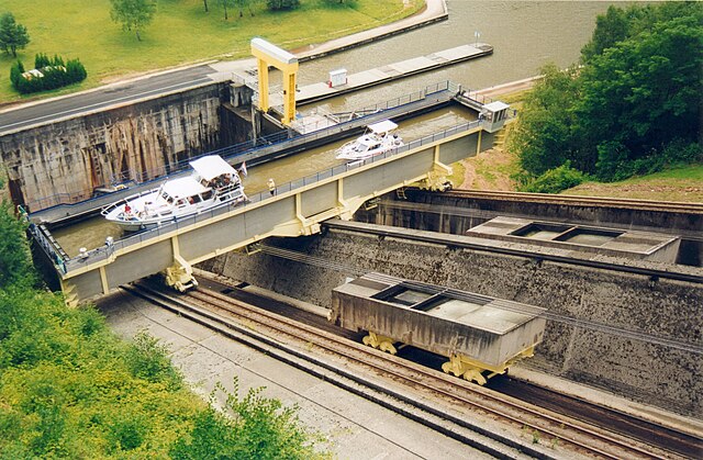
Français : Plan incliné de Saint-Louis-Arzviller
Nederlands: Hellend vlak van St-Louis-Arzviller
English: Saint-Louis-Arzviller inclined plane |
| Date | |
| Source | Photographie prise par GIRAUD Patrick |
| Author | User Calips on fr.wikipedia |
| Permission (Reusing this file) |
This file is licensed under the Creative Commons Attribution-Share Alike 1.0 Generic license.
|
| Other versions |
Originally from fr.wikipedia; description page was here
|
| Camera location | | View this and other nearby images on: OpenStreetMap |
|---|
(Uploaded using CommonsHelper or PushForCommons archive copy at the Wayback Machine)
File history
Click on a date/time to view the file as it appeared at that time.
| Date/Time | Thumbnail | Dimensions | User | Comment | |
|---|---|---|---|---|---|
| current | 09:07, 31 October 2006 | | 2,502 × 1,638 (1.63 MB) | Korrigan (talk | contribs) | {{Information| |Description= Plan incliné de Saint-Louis-Arzviller Photographie prise par GIRAUD Patrick |Source= |Date= |Author=User Calips on [http://fr.wikipedia.org fr.wikipedia] |Permission={{CC-BY-SA}} |other_versions= Originall |
You cannot overwrite this file.
File usage on Commons
The following page uses this file:
File usage on other wikis
The following other wikis use this file:
- Usage on als.wikipedia.org
- Usage on cs.wikipedia.org
- Usage on de.wikipedia.org
- Usage on en.wikipedia.org
- Usage on eo.wikipedia.org
- Usage on fr.wikipedia.org
- Transport fluvial en France
- Canal de la Marne au Rhin
- Plan incliné de Saint-Louis-Arzviller
- Ascenseur à bateaux
- Utilisateur:Calips
- Portail:Lorraine/Lumière
- Portail:Lorraine/Lumière-14
- Wikipédia:Le Bistro/18 juin 2006
- Wikipédia:Le Bistro/Galerie/2006
- Sentier de grande randonnée 532
- Wikipédia:Le Bistro/Galerie/Juin
- 1969 en Lorraine
- Usage on fr.wiktionary.org
- Usage on ja.wikipedia.org
- Usage on lb.wikipedia.org
- Usage on nl.wikipedia.org
- Usage on pl.wikipedia.org
- Usage on ru.wikipedia.org
- Usage on sv.wikipedia.org
- Usage on uk.wikipedia.org
- Usage on www.wikidata.org
- Usage on zh.wikipedia.org