File:Atl south well.jpg

Size of this preview: 448 × 599 pixels. Other resolutions: 179 × 240 pixels | 359 × 480 pixels | 574 × 768 pixels | 765 × 1,024 pixels | 1,342 × 1,795 pixels.
Original file (1,342 × 1,795 pixels, file size: 209 KB, MIME type: image/jpeg)
Captions
Captions
Add a one-line explanation of what this file represents
Summary edit
| Description |
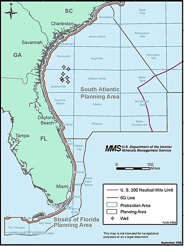
English: Map showing exploratory wells drilled for oil and gas off the US south Atlantic coast |
| Date | |
| Source | gomr.mms.gov |
| Author | U.S. Minerals Management Service |
Licensing edit
| This article or image contains material based on a work of a Minerals Management Service employee, created as part of that person's official duties. As a work of the U.S. federal government, such work is in the public domain in the United States. See MMS Disclaimer. |  |
Original upload log edit
The original description page was here. All following user names refer to en.wikipedia.
| Date/Time | Dimensions | User | Comment |
|---|---|---|---|
| 2009-02-14 15:09 | 1342×1795× (214494 bytes) | Plazak | {{Information |Description=Map showing exploratory wells drilled for oil and gas off the US south Atlantic coast |Source=http://www.gomr.mms.gov/homepg/offshore/atlocs/atl_south_well.pdf |Date=September 2008 |Author=US Minerals Management Service |Permiss |
File history
Click on a date/time to view the file as it appeared at that time.
| Date/Time | Thumbnail | Dimensions | User | Comment | |
|---|---|---|---|---|---|
| current | 20:30, 13 August 2015 | | 1,342 × 1,795 (209 KB) | Innotata (talk | contribs) | Transferred from en.wikipedia |
You cannot overwrite this file.
File usage on Commons
There are no pages that use this file.
File usage on other wikis
The following other wikis use this file:
- Usage on en.wikipedia.org