File:Atlas Van der Hagen-KW1049B10 100-Alpinae seu Foederatae RHAETIAE SUBDITARUMQUE ei Terrarum nova descriptio.jpeg

Original file (5,500 × 4,225 pixels, file size: 4.55 MB, MIME type: image/jpeg)
Captions
Captions
Summary edit
| Dirk Jansz van Santen: Atlas van Dirk van der Hagen (volledig, collectie KB)
|
||||||||||||||||||||||||||||
|---|---|---|---|---|---|---|---|---|---|---|---|---|---|---|---|---|---|---|---|---|---|---|---|---|---|---|---|---|
| Artist |
Auctoribus Fortinato Sprechero a Berneck. Eq. aur. & I.V.D. Ret. AC Phil. Cluverio Author: Auctoribus Fortinato Sprechero a Berneck. Eq. aur. & I.V.D. Ret. AC Phil. Cluverio Author: Evert Sijmons Z. Hamers Veldt sculp Publisher:
|
 | ||||||||||||||||||||||||||
| Title |
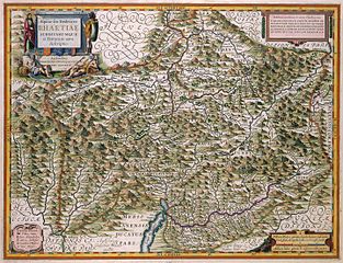
Alpinae seu Foederatae RHAETIAE SUBDITARUMQUE ei Terrarum nova descriptio |
|||||||||||||||||||||||||||
| Object type | map | |||||||||||||||||||||||||||
| Description |
Nederlands: Deze kaart van de Alpen van de Zwitserse kartograaf Fortunato Sprecher à Berneck werd in opdracht van Willem Jansz. Blaeu (1571-1638) gegraveerd door de graveur Evert Symonsz. Hamersveldt (geboren ca. 1591/1592) die tussen 1616 en 1643 in Amsterdam werkzaam was. De kaart werd in 1630 gepubliceerd in de allereerste atlas van Blaeu, de Atlas Appendix.; Rechtsboven een opdracht van Willem Jansz. Blaeu aan Adriaan Pauw.
English: This map of the Alps by the Swiss cartographer Fortunato Sprecher à Berneck was, under orders from Willem Jansz. Blaeu (1571-1638), engraved by Evert Symonsz. Hamersveldt (born c. 1591/1592) who was active in Amsterdam between 1616-1643. The map was published in Blaeus very first atlas, the Atlas Appendix (1630). |
|||||||||||||||||||||||||||
| Language |
Dutch |
|||||||||||||||||||||||||||
| Date | 1630 | |||||||||||||||||||||||||||
| Publication date |
circa |
|||||||||||||||||||||||||||
| Medium |
Nederlands: kopergravure
English: copper engraving print |
|||||||||||||||||||||||||||
| Dimensions | 38 x 50 cm | |||||||||||||||||||||||||||
| Collection |
|
|||||||||||||||||||||||||||
| Accession number |
Description of the Atlas Van der Hagen in the catalogue of the KB: http://opc4.kb.nl/DB=1/TTL=1/LNG=EN/PPN?PPN=353012750 |
|||||||||||||||||||||||||||
| Place of creation |
Netherlands |
|||||||||||||||||||||||||||
| Notes | KW1049B10_100 - Volume 1 | |||||||||||||||||||||||||||
| Related persons | Cluverius, Philip - Pauw, Adriaan - Hamersveldt, Evert Symonsz. - Willem Jansz. Blaeu - Sprecher à Berneck, Fortunato | |||||||||||||||||||||||||||
| Depicted locations | Alps - Switzerland | |||||||||||||||||||||||||||
| References | ||||||||||||||||||||||||||||
| Source/Photographer |
Source page at the Geheugen van Nederland / Memory of the Netherlands website.
|
|||||||||||||||||||||||||||
| Permission (Reusing this file) |
|
|||||||||||||||||||||||||||


File history
Click on a date/time to view the file as it appeared at that time.
| Date/Time | Thumbnail | Dimensions | User | Comment | |
|---|---|---|---|---|---|
| current | 20:36, 18 July 2015 | | 5,500 × 4,225 (4.55 MB) | OlafJanssen (talk | contribs) | GWToolset: Creating mediafile for OlafJanssen. |
You cannot overwrite this file.
File usage on Commons
The following 3 pages use this file: