File:Atlas du plan général de la ville de Paris - Sheet 63 - David Rumsey.jpg

Size of this preview: 800 × 566 pixels. Other resolutions: 320 × 226 pixels | 640 × 453 pixels | 1,024 × 724 pixels | 1,280 × 905 pixels | 2,560 × 1,811 pixels | 17,654 × 12,486 pixels.
Original file (17,654 × 12,486 pixels, file size: 35.8 MB, MIME type: image/jpeg)
Captions
Captions
Add a one-line explanation of what this file represents
Summary edit
| Warning | The original file is very high-resolution. It might not load properly or could cause your browser to freeze when opened at full size. |
|---|
| Title |
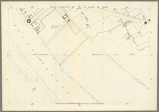
Atlas du plan général de la ville de Paris. |
|||||||||||||||||||||||
| Description |
English: Relief shown pictorially. "Dessiné et gravé par les cens. P.T. Bartholomé et A.J. Mathieu. Ecrit par Bellanger." Includes detailed index: "Table par ordre alphabétique des rues, cus-de-sacs, halles, marchés ..."- Sheets 49-50, 57-58, 65-67. Includes table of distances of the principal monuments used for the survey on which this map is based, and "Plan des opérations trigonometriques de la ville de Paris" which shows the survey lines, pl. 70-71. "Verniquet" signature stamped on verso of several leaves. The title page (not issued with most copies) includes a map of the city in 9 colors representing the growth of Paris in various epochs. This large Paris plan, divided into 72 parts, also contains, in the engraving, a "Table in alphabetical order of the Streets, Cul - de - sac, Passages, Places, Ports, Halles, ..." Points of station on different monuments and the Plan of the trigonometric operations of the city of Paris. The plan is published in the 1 / 1800th and represents the pre - revolutionary Parisian public streets and buildings. It is the first accurate mapping of Paris geometrically established and with a mathematically exact view of the capital, it will serve as a topographical background for most of the other plans made in the 19th century. Joseph Lalande, director of the Observatory, praises Verniquet's plan in these terms: "This plan, the work of which I have followed and admired for its accuracy, seems to me the most perfect work which has ever been executed in this way and is the only one which offers a mathematically exact view of the capital." The work of Verniquet was considerable - he built in a number of provinces of France, and especially in Burgundy, a great number of factories, bridges, roads and buildings remarkable for art, and solidity. Around 1774 he went to settle in Paris, where he executed his principal work, the plan of that city and its suburbs... An immense labor which occupied him for twenty-eight years, mostly at night because of street difficulties during the day, and for which he employed up to sixty engineers and more than eighty aides on horseback. |
|||||||||||||||||||||||
| Date | ||||||||||||||||||||||||
| Source | David Rumsey Historical Map Collection | |||||||||||||||||||||||
| Creator |
|
|||||||||||||||||||||||
| Geotemporal data | ||||||||||||||||||||||||
| Map location | Paris | |||||||||||||||||||||||
| Scale | 1: 2,000 | |||||||||||||||||||||||
| Georeferencing | If inappropriate please set warp_status = skip to hide. | |||||||||||||||||||||||
| Bibliographic data | ||||||||||||||||||||||||
| Publication |
Atlas du plan général de la ville de Paris, levé géométriquement par le cen Verniquet rapporté sur une échelle d'une demie ligne pour toise, divisée en 72 planches, compris les cartouches et plan des opérations trigonométriques. Dessiné et gravé par les cens Bartholomé et Mathieu. L'An IV. |
|||||||||||||||||||||||
| Language | french | |||||||||||||||||||||||
| Place of publication | Paris | |||||||||||||||||||||||
| Publisher |
Edme Verniquet |
|||||||||||||||||||||||
| Printed by |
A.J. Mathieu, P.T. Bartholomé & Bellanger |
|||||||||||||||||||||||
| Archival data | ||||||||||||||||||||||||
| Collection | David Rumsey Historical Map Collection | |||||||||||||||||||||||
| Medium | Atlas map | |||||||||||||||||||||||
.jpg)
Licensing edit
|
This work is in the public domain in its country of origin and other countries and areas where the copyright term is the author's life plus 100 years or fewer. | |
| This file has been identified as being free of known restrictions under copyright law, including all related and neighboring rights. | |
File history
Click on a date/time to view the file as it appeared at that time.
| Date/Time | Thumbnail | Dimensions | User | Comment | |
|---|---|---|---|---|---|
| current | 05:58, 14 January 2020 | | 17,654 × 12,486 (35.8 MB) | Paris 16 (talk | contribs) | User created page with UploadWizard |
You cannot overwrite this file.
File usage on Commons
There are no pages that use this file.