File:Atlas of Lake and Geauga Counties, Ohio - DPLA - fe3476ac55c4fc99f9df1bcf14a6ad07 (page 51).jpg

Size of this preview: 457 × 599 pixels. Other resolutions: 183 × 240 pixels | 366 × 480 pixels | 586 × 768 pixels | 781 × 1,024 pixels | 1,562 × 2,048 pixels | 2,593 × 3,399 pixels.
Original file (2,593 × 3,399 pixels, file size: 1.31 MB, MIME type: image/jpeg)
Captions
Captions
Add a one-line explanation of what this file represents
Summary
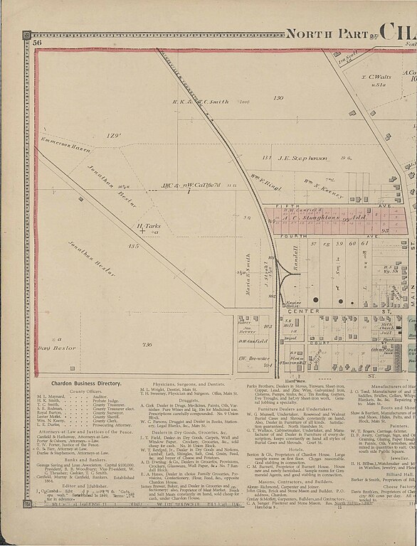
edit| Atlas of Lake and Geauga Counties, Ohio
( |
|||||||||||||||||||||
|---|---|---|---|---|---|---|---|---|---|---|---|---|---|---|---|---|---|---|---|---|---|
| Creator | Lake, D. J | ||||||||||||||||||||
| Title |
Atlas of Lake and Geauga Counties, Ohio |
||||||||||||||||||||
| Description |
Atlas of Lake and Geauga counties, Ohio from actual surveys by and under the directions of D.J. Lake, assisted by B.N. Griffing...[et al.]. |
||||||||||||||||||||
| Date | 1874 | ||||||||||||||||||||
| Collection |
|
||||||||||||||||||||
| Source/Photographer |
|
||||||||||||||||||||
| Permission (Reusing this file) |
|
||||||||||||||||||||
| Standardized rights statement |
|
||||||||||||||||||||


.jpg&action=edit§ion=1)
File history
Click on a date/time to view the file as it appeared at that time.
| Date/Time | Thumbnail | Dimensions | User | Comment | |
|---|---|---|---|---|---|
| current | 00:27, 25 January 2022 | | 2,593 × 3,399 (1.31 MB) | DPLA bot (talk | contribs) | Uploading DPLA ID fe3476ac55c4fc99f9df1bcf14a6ad07 |
You cannot overwrite this file.
File usage on Commons
The following page uses this file:
.jpg)
.jpg&oldid=832985329)