File:Australia-Map-SA-LGA-PortPirie.png

Size of this preview: 526 × 599 pixels. Other resolutions: 211 × 240 pixels | 421 × 480 pixels | 645 × 735 pixels.
Original file (645 × 735 pixels, file size: 8 KB, MIME type: image/png)
Captions
Captions
Add a one-line explanation of what this file represents
Summary
edit
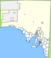
| Description | Map of South Australia/Australia, LGA of Port Pirie Regional Council highlighted |
| Date | |
| Source | Own work |
| Author | User:Bill da Flute |
Licensing
edit
| I, the copyright holder of this work, release this work into the public domain. This applies worldwide. In some countries this may not be legally possible; if so: I grant anyone the right to use this work for any purpose, without any conditions, unless such conditions are required by law. |
File history
Click on a date/time to view the file as it appeared at that time.
| Date/Time | Thumbnail | Dimensions | User | Comment | |
|---|---|---|---|---|---|
| current | 19:31, 7 November 2008 | | 645 × 735 (8 KB) | Bill da Flute (talk | contribs) | == Beschreibung == {{Information |Description=Map of South Australia/Australia, LGA of Port Pirie Regional Council highlighted |Source=own work |Date=November 6, 2008 |Author=User:Bill da Flute |Permission= |other_versions= }} == Licensing == {{PD-se |
You cannot overwrite this file.
File usage on Commons
There are no pages that use this file.
File usage on other wikis
The following other wikis use this file:
- Usage on ceb.wikipedia.org
- Usage on de.wikipedia.org
- Usage on fr.wikipedia.org
- Usage on it.wikipedia.org
- Usage on sv.wikipedia.org
- Usage on www.wikidata.org