File:Australia South Australia Riverland location map.svg

Size of this PNG preview of this SVG file: 609 × 276 pixels. Other resolutions: 320 × 145 pixels | 640 × 290 pixels | 1,024 × 464 pixels | 1,280 × 580 pixels | 2,560 × 1,160 pixels.
Original file (SVG file, nominally 609 × 276 pixels, file size: 1.35 MB)
Captions
Captions
Add a one-line explanation of what this file represents
Summary
edit
| Description |
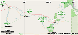
English: A location map for the w:Riverland region of South Australia
set-geo-bounds 139.5,-34.5,141.1,-33.9 |
| Date | |
| Source | Created by me using Maperitive and OpenStreetMap data |
| Author | User:ScottDavis and OpenStreetMap contributors |
Licensing
edit
| This work contains information from OpenStreetMap, which is made available under the Open Database License (ODbL).
The ODbL does not require any particular license for maps produced from ODbL data. Prior to 1 August 2020, map tiles produced by the OpenStreetMap Foundation were licensed under the CC-BY-SA-2.0 license. Maps produced by other people may be subject to other licences. |
This file is licensed under the Creative Commons Attribution-Share Alike 4.0 International license.
- You are free:
- to share – to copy, distribute and transmit the work
- to remix – to adapt the work
- Under the following conditions:
- attribution – You must give appropriate credit, provide a link to the license, and indicate if changes were made. You may do so in any reasonable manner, but not in any way that suggests the licensor endorses you or your use.
- share alike – If you remix, transform, or build upon the material, you must distribute your contributions under the same or compatible license as the original.
The data included in this document is from www.openstreetmap.org. The data is made available under ODbL.
File history
Click on a date/time to view the file as it appeared at that time.
| Date/Time | Thumbnail | Dimensions | User | Comment | |
|---|---|---|---|---|---|
| current | 12:46, 23 February 2015 | | 609 × 276 (1.35 MB) | ScottDavis (talk | contribs) | User created page with UploadWizard |
You cannot overwrite this file.
File usage on Commons
There are no pages that use this file.
File usage on other wikis
The following other wikis use this file:
- Usage on ar.wikipedia.org
- Usage on en.wikipedia.org
- Usage on si.wikipedia.org
- Usage on uz.wikipedia.org
- Usage on vi.wikipedia.org