File:Australia locator-MJC coloured (labelled).png
No higher resolution available.
Australia_locator-MJC_coloured_(labelled).png (497 × 450 pixels, file size: 97 KB, MIME type: image/png)
Captions
Captions
locatioceanic images
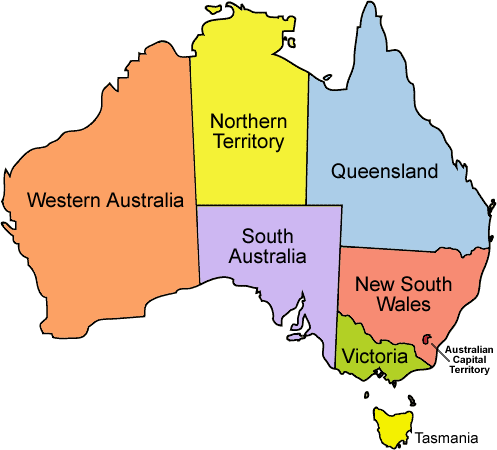
| Description | Map displaying the outline of Australia with each of the states and territories coloured and labelled, using Image:Australia locator-MJC.png but whitespace surrounding the outline removed, derived from Image:Tasmania locator-MJC.png. |
| Date | Image:Tasmania locator-MJC.png created October 10, 2005, this version created December 28, 2007. |
| Source | Own work, derived from Image:Australia locator-MJC.png and Image:Tasmania locator-MJC.png. |
| Author | Spebi, Image:Tasmania locator-MJC.png by User:Martyman. |
| Other versions |
Derivative works of this file: Australia locator-MJC coloured (labelled) NL.png Image:Australia locator-MJC.png, Image:Australia locator-MJC (no whitespace).png |
_NL.png)
.png)
| This file is licensed under the Creative Commons Attribution-Share Alike 3.0 Unported license. Subject to disclaimers. | ||
| ||
| This licensing tag was added to this file as part of the GFDL licensing update. |

|
Permission is granted to copy, distribute and/or modify this document under the terms of the GNU Free Documentation License, Version 1.2 or any later version published by the Free Software Foundation; with no Invariant Sections, no Front-Cover Texts, and no Back-Cover Texts. A copy of the license is included in the section entitled GNU Free Documentation License. Subject to disclaimers. |

|
This locator map image could be re-created using vector graphics as an SVG file. This has several advantages; see Commons:Media for cleanup for more information. If an SVG form of this image is available, please upload it and afterwards replace this template with
{{vector version available|new image name}}.
It is recommended to name the SVG file “Australia locator-MJC coloured (labelled).svg”—then the template Vector version available (or Vva) does not need the new image name parameter. |
File history
Click on a date/time to view the file as it appeared at that time.
| Date/Time | Thumbnail | Dimensions | User | Comment | |
|---|---|---|---|---|---|
| current | 00:06, 28 December 2007 | | 497 × 450 (97 KB) | Seb26 (talk | contribs) | {{Information |Description = Map displaying the outline of Australia with each of the states and territories coloured and labelled, using Image:Australia locator-MJC.png but whitespace surrounding the outline removed, derived fro |
You cannot overwrite this file.
File usage on Commons
The following page uses this file:
File usage on other wikis
The following other wikis use this file:
- Usage on ar.wikipedia.org
- Usage on cs.wikipedia.org
- Usage on de.wikivoyage.org
- Usage on en.wikipedia.org
- Usage on fi.wikipedia.org
- Usage on fr.wikipedia.org
- Usage on hy.wikipedia.org
- Usage on nl.wikipedia.org
- Usage on no.wikipedia.org
.png&oldid=807775384)