File:Austria Burgenland location map.svg

Size of this PNG preview of this SVG file: 378 × 599 pixels. Other resolutions: 151 × 240 pixels | 303 × 480 pixels | 484 × 768 pixels | 646 × 1,024 pixels | 1,291 × 2,048 pixels | 975 × 1,546 pixels.
Original file (SVG file, nominally 975 × 1,546 pixels, file size: 248 KB)
Captions
Captions
Add a one-line explanation of what this file represents
Summary
edit| Description |
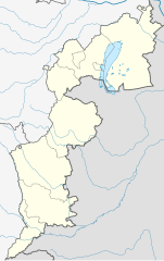
Deutsch: Positionskarte des Burgenlands
Quadratische Plattkarte. Geographische Begrenzung der Karte:
English: Location map of Burgenland
Equirectangular projection. Geographic limits of the map:
|
| Source |
Own work, based on maps-for-free.com and File:Karte Aut Bgld MA.png This W3C-unspecified vector image was created with Inkscape . |
| Author | Rosso Robot |
| Other versions |
|

Licensing
edit
I, the copyright holder of this work, hereby publish it under the following licenses:
This file is licensed under the Creative Commons Attribution-Share Alike 3.0 Unported license.
- You are free:
- to share – to copy, distribute and transmit the work
- to remix – to adapt the work
- Under the following conditions:
- attribution – You must give appropriate credit, provide a link to the license, and indicate if changes were made. You may do so in any reasonable manner, but not in any way that suggests the licensor endorses you or your use.
- share alike – If you remix, transform, or build upon the material, you must distribute your contributions under the same or compatible license as the original.

|
Permission is granted to copy, distribute and/or modify this document under the terms of the GNU Free Documentation License, Version 1.2 or any later version published by the Free Software Foundation; with no Invariant Sections, no Front-Cover Texts, and no Back-Cover Texts. A copy of the license is included in the section entitled GNU Free Documentation License. |
You may select the license of your choice.
File history
Click on a date/time to view the file as it appeared at that time.
| Date/Time | Thumbnail | Dimensions | User | Comment | |
|---|---|---|---|---|---|
| current | 20:11, 25 February 2012 | | 975 × 1,546 (248 KB) | NordNordWest (talk | contribs) | correct projection |
| 20:08, 25 February 2012 |  | 975 × 1,546 (248 KB) | NordNordWest (talk | contribs) | upd, correct projection | |
| 09:42, 27 May 2009 |  | 493 × 837 (87 KB) | Rosso Robot (talk | contribs) | correction in order of the template colour change of same administrative layer | |
| 14:29, 23 May 2009 |  | 493 × 837 (88 KB) | Rosso Robot (talk | contribs) | uploaded plain-svg not inkscape-svg | |
| 14:28, 23 May 2009 |  | 493 × 837 (95 KB) | Rosso Robot (talk | contribs) | earased background picture | |
| 14:25, 23 May 2009 |  | 493 × 837 (95 KB) | Rosso Robot (talk | contribs) | {{Information |Description={{de|1=Positionskarte von Wien Quadratische Plattkarte. Geographische Begrenzung der Karte: * N: 48.13797° N * S: 48.82685° N * W: 16.97240° O * O: 16.17266° O}} {{en|1=Location map of Vienna Equi |
You cannot overwrite this file.
File usage on Commons
The following 4 pages use this file:
File usage on other wikis
The following other wikis use this file:
- Usage on ba.wikipedia.org
- Usage on bg.wikipedia.org
- Usage on cs.wikipedia.org
- Usage on cv.wikipedia.org
- Usage on de.wikipedia.org
- Pappelstadion
- Diskussion:Liste jüdischer Friedhöfe in Österreich
- Bärenhöhle (Winden am See)
- Wikipedia:Kartenwerkstatt/Positionskarten/Europa
- Vorlage:Positionskarte Österreich Burgenland
- Flugplatz Punitz-Güssing
- Leuchtturm Podersdorf
- Österreichische Fußballmeisterschaft 2012/13
- Windpark Andau/Halbturn
- Österreichische Fußballmeisterschaft 2013/14
- Heidebodenstadion
- St. Martins Therme & Lodge
- Österreichische Fußballmeisterschaft 2015/16
- Österreichische Fußballmeisterschaft 2016/17
- Sonnenseestadion
- Benutzer:XaviYuahanda/Profiklubs
- Österreichische Fußballmeisterschaft 2017/18
- Österreichische Fußballmeisterschaft 2018/19
- Liste der Golfplätze des Burgenlandes
- Benutzer:XaviYuahanda/201920
- Benutzer:D-Kuru/baustellen/Liste der Soldatenfriedhöfe in Österreich/Burgenland
- Österreichische Fußballmeisterschaft 2020/21
- Steppentierpark Pamhagen
- Österreichische Fußballmeisterschaft 2021/22
- Leuchtturm Breitenbrunn
- Flugplatz Pinkafeld
- Österreichische Fußballmeisterschaft 2022/23
- Österreichische Fußballmeisterschaft 2023/24
- Truppenübungsplatz Bruckneudorf
- Österreichische Fußballmeisterschaft 2024/25
- Usage on en.wikipedia.org
View more global usage of this file.