File:Ayres Hall, University of Tennessee at Knoxville, Fort Sanders, Knoxville, TN - 52497257061.jpg

Size of this preview: 450 × 600 pixels. Other resolutions: 180 × 240 pixels | 360 × 480 pixels | 576 × 768 pixels | 768 × 1,024 pixels | 1,536 × 2,048 pixels | 2,880 × 3,840 pixels.
Original file (2,880 × 3,840 pixels, file size: 4.52 MB, MIME type: image/jpeg)
Captions
Captions
Add a one-line explanation of what this file represents
Summary
edit
| Description |
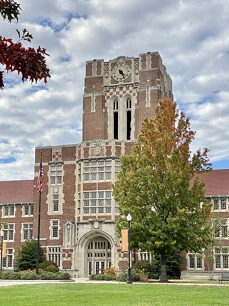
English: Built between 1919 and 1921, this Collegiate Gothic Revival-style building was designed by Miller, Fullenwider and Dowling and named for the former President of the University of Tennessee, Brown Ayres (1856–1919), whom served as university president from 1904-19. The building replaced the Old College Building, built in 1828, as well as the East College and West College buildings, which were built prior to the US Civil War and were among the oldest buildings on campus, and marked the start of a major campus redevelopment program that extended well into the mid-20th Century that replaced most of the 19th Century buildings with larger Collegiate Gothic Revival-style buildings that define the campus today, with only the South College Building remaining from the time prior to this redevelopment. The building features a central iconic Gothic Revival-style tower with limestone trim, clock faces, an open belfry, and crenellated parapet, which sits on the central wing of the building which features a low slope roof surrounded by a parapet, and entrances on the front and rear with portals and decorative surrounds below multi-story oriel windows. The central wing is flanked by two side wings which feature red shingle gabled roofs, large banks of windows, limestone trim, and several side entrances to the building. Ayres Hall presently houses the Mathematics Department of the University of Tennessee and was rehabilitated between 2008 and 2011, adding several features to the building that were originally planned but never implemented. The building was listed on the National Register of Historic Places in 2012. |
| Date | |
| Source | https://www.flickr.com/photos/59081381@N03/52497257061/ |
| Author | w_lemay |
| Camera location | | View this and other nearby images on: OpenStreetMap |
|---|
Licensing
edit
This file is licensed under the Creative Commons Attribution-Share Alike 2.0 Generic license.
- You are free:
- to share – to copy, distribute and transmit the work
- to remix – to adapt the work
- Under the following conditions:
- attribution – You must give appropriate credit, provide a link to the license, and indicate if changes were made. You may do so in any reasonable manner, but not in any way that suggests the licensor endorses you or your use.
- share alike – If you remix, transform, or build upon the material, you must distribute your contributions under the same or compatible license as the original.
| This image was originally posted to Flickr by w_lemay at https://flickr.com/photos/59081381@N03/52497257061. It was reviewed on 8 March 2023 by FlickreviewR 2 and was confirmed to be licensed under the terms of the cc-by-sa-2.0. |
File history
Click on a date/time to view the file as it appeared at that time.
| Date/Time | Thumbnail | Dimensions | User | Comment | |
|---|---|---|---|---|---|
| current | 17:50, 8 March 2023 | | 2,880 × 3,840 (4.52 MB) | Ser Amantio di Nicolao (talk | contribs) | Uploaded a work by w_lemay from https://www.flickr.com/photos/59081381@N03/52497257061/ with UploadWizard |
You cannot overwrite this file.
File usage on Commons
There are no pages that use this file.