File:B15a a4.jpg

Size of this preview: 800 × 527 pixels. Other resolutions: 320 × 211 pixels | 640 × 421 pixels | 1,024 × 674 pixels | 1,280 × 843 pixels | 2,025 × 1,333 pixels.
Original file (2,025 × 1,333 pixels, file size: 427 KB, MIME type: image/jpeg)
Captions
Captions
Add a one-line explanation of what this file represents
Summary
edit
| Description |
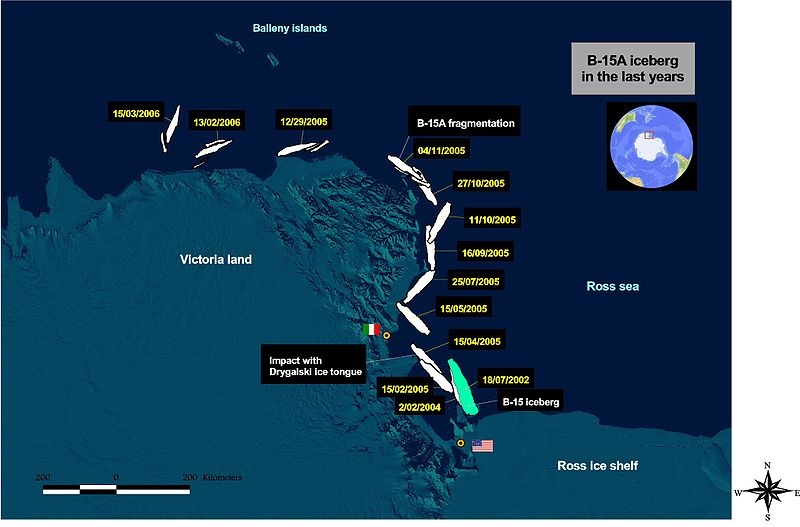
Found on Wikipedia.en GIS image showing the position of B-15A iceberg from 2003 to March 2006. Image made by Luca Pietranera. Information on the iceberg poositions derived by NASA-MODIS images (MODIS Rapid Response Rroject at NASA/GSI) and European Space Agency (ESA) ENVISAT,MERIS and ASAR sensors images. The background is a part of the MODIS mosaic of Antarctica (Haran, T., J. Bohlander, T. Scambos, and M. Fahnestock compilers. 2005. MODIS mosaic of Antarctica (MOA) image map. Boulder, CO, USA: National Snow and Ice Data Center. Digital media).Italian station "Mario Zucchelli" and US McMurdo Station are highlighted on the map. |
| Date | 17 January 2007 (original upload date) |
| Source | No machine-readable source provided. Own work assumed (based on copyright claims). |
| Author | No machine-readable author provided. TCY assumed (based on copyright claims). |
Licensing
edit
| I, the copyright holder of this work, release this work into the public domain. This applies worldwide. In some countries this may not be legally possible; if so: I grant anyone the right to use this work for any purpose, without any conditions, unless such conditions are required by law. |
File history
Click on a date/time to view the file as it appeared at that time.
| Date/Time | Thumbnail | Dimensions | User | Comment | |
|---|---|---|---|---|---|
| current | 18:24, 17 January 2007 | | 2,025 × 1,333 (427 KB) | TCY (talk | contribs) | == Summary == Found on Wikipedia.en GIS image showing the position of B-15A iceberg from 2003 to March 2006. Image made by Luca Pietranera. Information on the iceberg poositions derived by NASA-MODIS images ([http://rapidfire.sci.gsfc.nasa.gov/ MODIS |
You cannot overwrite this file.
File usage on Commons
There are no pages that use this file.
File usage on other wikis
The following other wikis use this file:
- Usage on de.wikipedia.org
- Usage on en.wikipedia.org
- Usage on et.wikipedia.org
- Usage on fa.wikipedia.org
- Usage on fi.wikipedia.org
- Usage on fr.wikipedia.org
- Usage on hy.wikipedia.org
- Usage on id.wikipedia.org
- Usage on ja.wikipedia.org
- Usage on ko.wikipedia.org
- Usage on la.wikipedia.org
- Usage on nn.wikipedia.org
- Usage on pl.wikipedia.org
- Usage on pt.wikipedia.org
- Usage on ru.wikipedia.org
- Usage on th.wikipedia.org
- Usage on tr.wikipedia.org
- Usage on uk.wikipedia.org