File:BAND TOWER AND MOSQUE-Dr. Murali Mohan Gurram.jpg

Original file (2,592 × 1,944 pixels, file size: 2.96 MB, MIME type: image/jpeg)
Captions
Captions
Summary
edit
| Description |
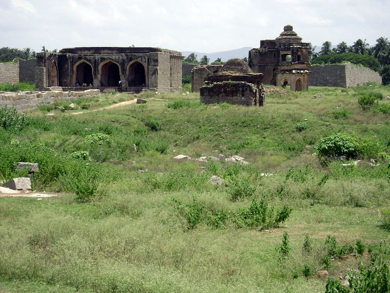
English: Danaik's Enclosure. To the right is the Band tower and to left is the mosque.
Arguably one of the most ambiguous localities in Hampi, the Danaik’s Enclosure (also called Dannayaka's enclosure) is a systematically partitioned campus. Archeologists and historians are at different opinions about the erstwhile status of this area. The arguments vary widely. A section of the experts believe that it is here the state mint was located located. And hence a portion of the campus is called the Mint. Others believe that this was the area of the city’s administrative and high-ranking officers. That the word Danaik refers to commander in chief or the Mayor of the city. The seat of the Danaik in the enclosure as evidence supports this argument. Yet another school of archeologists believes that this had been used as a military training area for the elite army. The presence of the Mosque inside the campus is shown as the presence of Muslim trainers (horse riding) from the northern provinces. Also supports this thesis is the presence of the array of granaries at the north and the Bhojanasala (Dining Hall) at the south of this area. Every now and then new finds are made among the Hampi ruins, – a hitherto unknown pond, a temple, a palace structure or an inscription on a stone- questioning the current assumptions. For example, the recent discovery of an ancient Shiva temple by the Archaeological Survey of India. The temple was found buried just west of the Danaik’s Enclosure area. A sequence of events started with clearing of this area of bushes and shrubs led to the unearthing of this temple, questioning a lot of established assumptions. To an unsuspecting visitor this is a sprawling compound with numerous basement of palace like structures, crisscrossing tracks, and a network of partition walls. It’s an open barren expanse with confusing exits and entrances. For the sake of simplicity and understanding the Danaik’s Enclosure area may be split into three sections. The northwestern area that houses the Mohammadan Watch Tower, the Mosque, the Band Tower, the Idgah (an open payer area), the seat of Danaik and the recently discovered Shiva temple just outside of it. The northeast area houses the palace base of Vira Harihara; And the southeast section that is popularly known as the Mint area. The best option to enter the Danaik’s Enclosure is through the modest entrance at its northern wall. The unpaved road that runs along the north edge of the Underground Shiva Temple can take you to the Danaik’s Enclosure. From the Underground Temple, a few feet down towards east the path makes a left turn around the recently excavated basements. A few feet down the path the path again takes a rightward turn. You can spot the exteriors of the Mohammadan Watch Tower at the left corner with the balcony projecting towards your path. The entrance to the enclosure is located just after this point. The enclosure area is roughly about 200 meters wide and 800 meters long. Motor vehicles are not allowed beyond the above mentioned entrance point. However you may take your bicycle and the mopeds inside. The whole compound is strewn with thorny creeper plants. Keep as much as possible to the trodden trails to avoid a flat tire. One may not get lost, but it’s a bit puzzling to trace the complex pathways. The area is open to visitors from sunrise to sunset. No entrance fees or camera fees. Courtesy hampi.in
|
||
| Date | |||
| Source | Own work | ||
| Author | Dr Murali Mohan Gurram |
Licensing
edit
- You are free:
- to share – to copy, distribute and transmit the work
- to remix – to adapt the work
- Under the following conditions:
- attribution – You must give appropriate credit, provide a link to the license, and indicate if changes were made. You may do so in any reasonable manner, but not in any way that suggests the licensor endorses you or your use.
- share alike – If you remix, transform, or build upon the material, you must distribute your contributions under the same or compatible license as the original.

|
This image was uploaded as part of Wiki Loves Monuments 2013.
|
 |
File history
Click on a date/time to view the file as it appeared at that time.
| Date/Time | Thumbnail | Dimensions | User | Comment | |
|---|---|---|---|---|---|
| current | 18:20, 14 September 2013 | | 2,592 × 1,944 (2.96 MB) | Dr Murali Mohan Gurram (talk | contribs) | User created page with UploadWizard |
You cannot overwrite this file.
File usage on Commons
There are no pages that use this file.