File:BANZSL map.png

Size of this preview: 800 × 351 pixels. Other resolutions: 320 × 140 pixels | 640 × 281 pixels | 1,425 × 625 pixels.
Original file (1,425 × 625 pixels, file size: 36 KB, MIME type: image/png)
Captions
Captions
Add a one-line explanation of what this file represents
| Description |
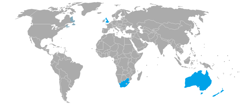
English: Countries where BANZSL is spoken. It is moribund in Canada. |
||
| Date | kwami (talk)06:46, 15 April 2012 (UTC) | ||
| Source | Own work derived from BlankMap-World-v2.png | ||
| Author | Kwamikagami | ||
| Permission (Reusing this file) |
Kwamikagami at English Wikipedia, the copyright holder of this work, hereby publishes it under the following licenses:
This file is licensed under the Creative Commons Attribution-Share Alike 3.0 Unported license. Attribution: Kwamikagami at English Wikipedia
You may select the license of your choice. |


|
This linguistic map image could be re-created using vector graphics as an SVG file. This has several advantages; see Commons:Media for cleanup for more information. If an SVG form of this image is available, please upload it and afterwards replace this template with
{{vector version available|new image name}}.
It is recommended to name the SVG file “BANZSL map.svg”—then the template Vector version available (or Vva) does not need the new image name parameter. |
Original upload log edit
Transferred from en.wikipedia to Commons by ThomasPusch using CommonsHelper.
The original description page was here. All following user names refer to en.wikipedia.
- 2012-04-15 06:46 Kwamikagami 1425×625× (54171 bytes) Uploading a self-made file using [[Wikipedia:File_Upload_Wizard|File Upload Wizard]]
File history
Click on a date/time to view the file as it appeared at that time.
| Date/Time | Thumbnail | Dimensions | User | Comment | |
|---|---|---|---|---|---|
| current | 11:28, 10 March 2022 | | 1,425 × 625 (36 KB) | Piperium (talk | contribs) | Fixed another SVG error on east coast of africa |
| 11:25, 10 March 2022 |  | 1,425 × 625 (36 KB) | Piperium (talk | contribs) | Removed erroneous lines resultant of SVG errors. | |
| 06:53, 18 July 2020 |  | 1,425 × 625 (36 KB) | Maphobbyist (talk | contribs) | South Sudan border | |
| 20:58, 9 January 2013 |  | 1,425 × 625 (53 KB) | File Upload Bot (Magnus Manske) (talk | contribs) | Transfered from en.wikipedia by User:ThomasPusch using CommonsHelper |
You cannot overwrite this file.
File usage on Commons
The following 2 pages use this file:
File usage on other wikis
The following other wikis use this file:
- Usage on ca.wikipedia.org
- Usage on en.wikipedia.org
- Usage on eo.wikipedia.org
- Usage on es.wikipedia.org
- Usage on fa.wikipedia.org
- Usage on fr.wikipedia.org
- Usage on id.wikipedia.org
- Usage on it.wikipedia.org
- Usage on ja.wikipedia.org
- Usage on nl.wikipedia.org
- Usage on ru.wikipedia.org
- Usage on zh.wikipedia.org