File:BART system map effective September 2002.pdf

Original file (600 × 750 pixels, file size: 221 KB, MIME type: application/pdf)
Captions
Captions
Summary edit
| Description |
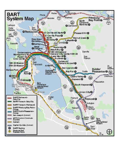
English: BART system map accurate to the September 9, 2002 service changes |
|||
| Date | ||||
| Source | BART System Map | |||
| Author | San Francisco Bay Area Rapid Transit District | |||
| Permission (Reusing this file) |
|

File history
Click on a date/time to view the file as it appeared at that time.
| Date/Time | Thumbnail | Dimensions | User | Comment | |
|---|---|---|---|---|---|
| current | 11:42, 24 January 2019 |  | 600 × 750 (221 KB) | Pi.1415926535 (talk | contribs) | == {{int:filedesc}} == {{Information |description ={{en|1=BART system map accurate to the September 9, 2002 service changes}} |date =2002-09-09 |source =[https://archive.org/details/bart-map-2002-09-27 BART System Map] |author =San Francisco Bay Area Rapid Transit District |permission ={{PD-CAGov}} }} 20020909 Category:BART in 2002 |
You cannot overwrite this file.
File usage on Commons
The following 4 pages use this file: