File:BD Map admin de.svg

Size of this PNG preview of this SVG file: 433 × 599 pixels. Other resolutions: 173 × 240 pixels | 347 × 480 pixels | 555 × 768 pixels | 741 × 1,024 pixels | 1,481 × 2,048 pixels | 779 × 1,077 pixels.
Original file (SVG file, nominally 779 × 1,077 pixels, file size: 271 KB)
Captions
Captions
Add a one-line explanation of what this file represents
Rangpur
Summary
edit| Description |
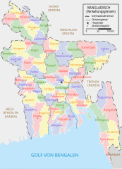
Deutsch: Verwaltungsgliederung von Bangladesch. বাংলা: বাংলাদেশের প্রশাসনিক মানচিত্র English: Administrative Map of Bangladesh. |
| Date | |
| Source | Own work |
| Author | (German translation + some graphical modifications made by Furfur) |
| Other versions |
|


While creating this map I have drawn inspiration and reference from works of Rarelibra (here) and Usingha (here) and several online maps:LGED, GoB archive copy at the Wayback Machine, Banglapedia. Armanaziz 08:41, 30 July 2007 (UTC)

|
This SVG file contains embedded text that can be translated into your language, using any capable SVG editor, text editor or the SVG Translate tool. For more information see: About translating SVG files. |
Licensing
edit
I, Armanaziz, the copyright holder of this work, hereby publishes it under the following licenses:

|
Permission is granted to copy, distribute and/or modify this document under the terms of the GNU Free Documentation License, Version 1.2 or any later version published by the Free Software Foundation; with no Invariant Sections, no Front-Cover Texts, and no Back-Cover Texts. A copy of the license is included in the section entitled GNU Free Documentation License. |
| This file is licensed under the Creative Commons Attribution-Share Alike 3.0 Unported license. | ||
| Attribution: I, Armanaziz | ||
| ||
| This licensing tag was added to this file as part of the GFDL licensing update. |
This file is licensed under the Creative Commons Attribution 2.5 Generic license.
Attribution: I, Armanaziz
- You are free:
- to share – to copy, distribute and transmit the work
- to remix – to adapt the work
- Under the following conditions:
- attribution – You must give appropriate credit, provide a link to the license, and indicate if changes were made. You may do so in any reasonable manner, but not in any way that suggests the licensor endorses you or your use.
You may select the license of your choice.
This W3C-unspecified vector image was created with Inkscape .
This W3C-unspecified vector image was created with Adobe Illustrator.
File history
Click on a date/time to view the file as it appeared at that time.
| Date/Time | Thumbnail | Dimensions | User | Comment | |
|---|---|---|---|---|---|
| current | 09:19, 23 February 2016 | | 779 × 1,077 (271 KB) | NordNordWest (talk | contribs) | c |
| 08:59, 23 February 2016 |  | 779 × 1,077 (271 KB) | NordNordWest (talk | contribs) | upd | |
| 19:40, 16 July 2015 |  | 779 × 1,077 (275 KB) | Furfur (talk | contribs) | kleine Verbesserungen | |
| 11:35, 4 July 2015 |  | 771 × 1,071 (290 KB) | Furfur (talk | contribs) | Details | |
| 11:23, 4 July 2015 |  | 779 × 1,077 (290 KB) | Furfur (talk | contribs) | == {{int:filedesc}} == {{Information |Description={{de|1=Verwaltungsgliederung von Bangladesch.}}{{en|1=Administrative Map of Bangladesh.}} |Source={{Own}} |Date=2007-07-30 |Author= Armanaziz (German translation + some graphical modi... |
You cannot overwrite this file.
File usage on Commons
The following 4 pages use this file:
File usage on other wikis
The following other wikis use this file:
- Usage on de.wikipedia.org
- Usage on frr.wikipedia.org