File:BMI-30-Worldmap-2014.svg

Size of this PNG preview of this SVG file: 800 × 382 pixels. Other resolutions: 320 × 153 pixels | 640 × 306 pixels | 1,024 × 489 pixels | 1,280 × 612 pixels | 2,560 × 1,223 pixels | 1,620 × 774 pixels.
Original file (SVG file, nominally 1,620 × 774 pixels, file size: 470 KB)
Captions
Captions
Add a one-line explanation of what this file represents
Summary edit
| Description |
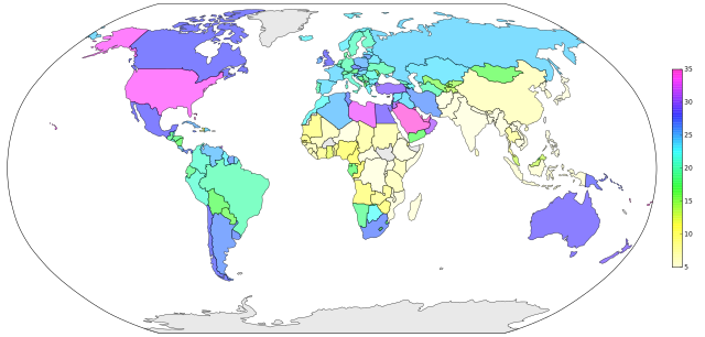
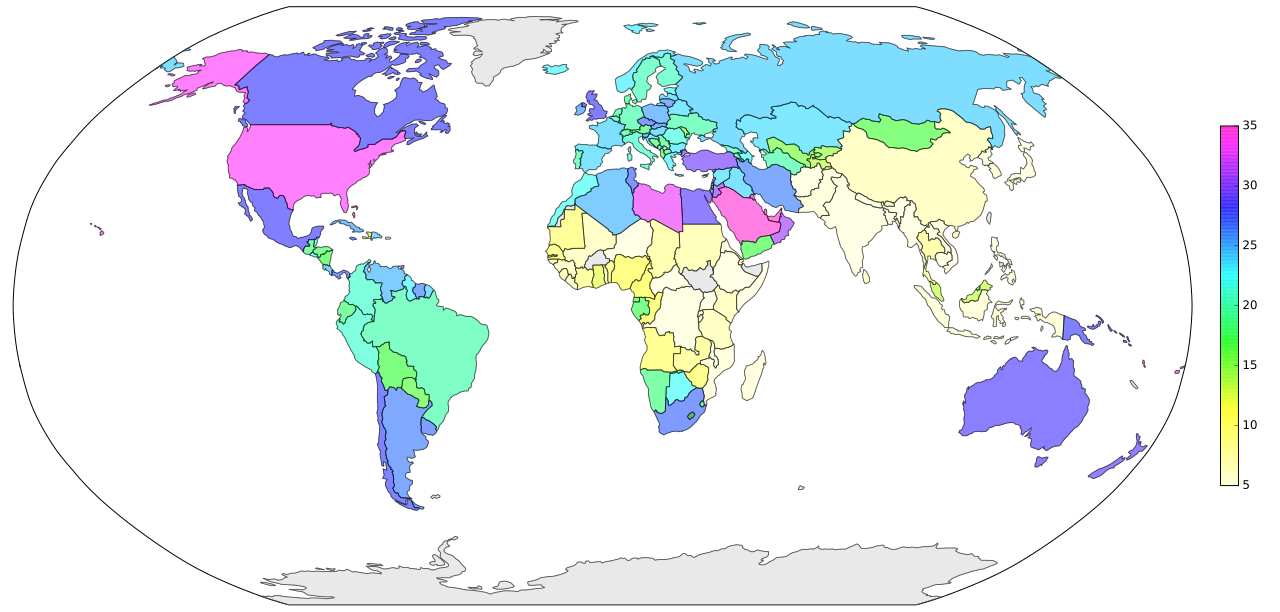
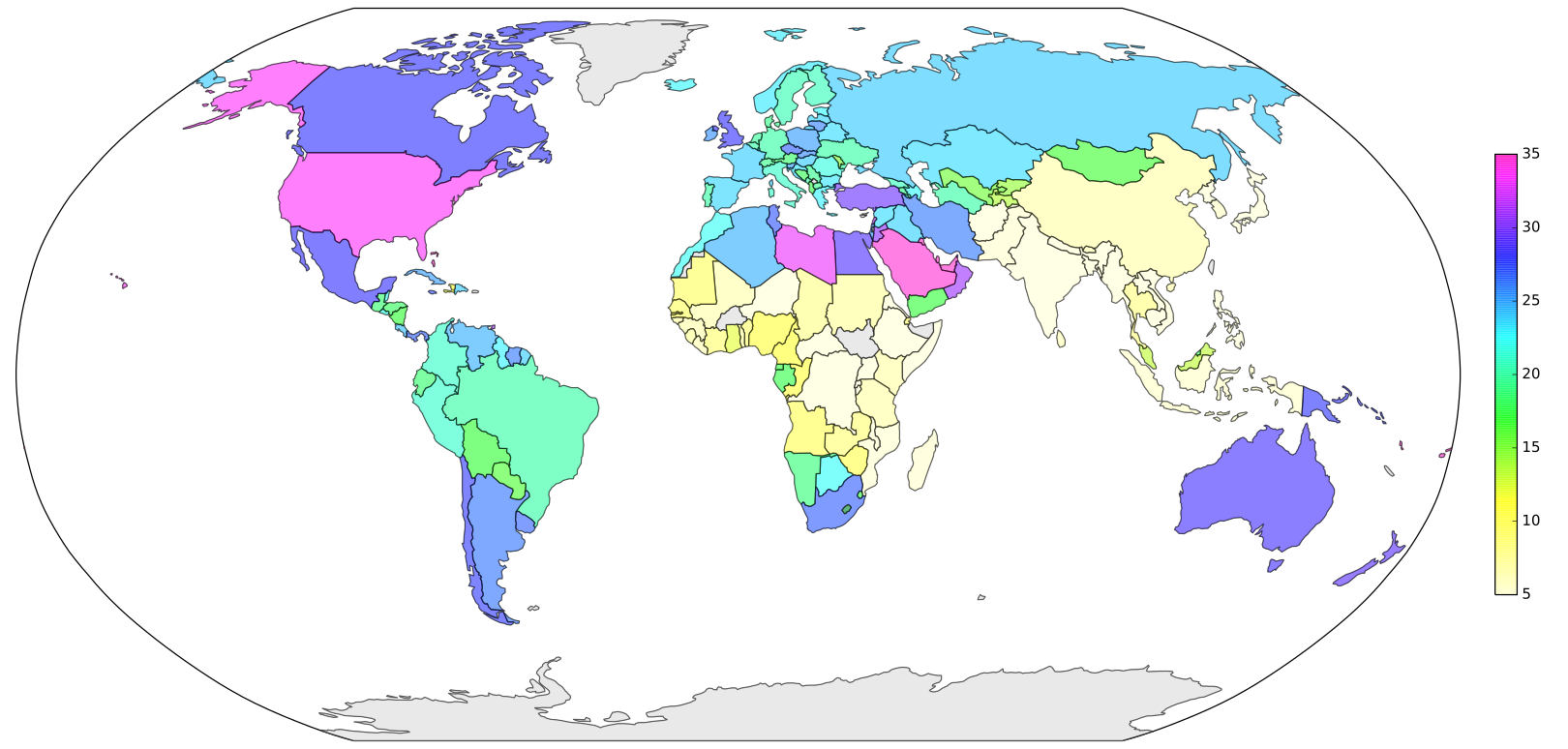
English: Percentage of people with a body mass index ≥ 30kg/m2 per country in 2014
Data from http://www.who.int/gho/ncd/risk_factors/overweight/en/ http://obesity.procon.org/view.resource.php?resourceID=006032 Country shapes from http://www.naturalearthdata.com/downloads/110m-cultural-vectors Created with Python and Matplotlib Basemap Toolkit. |
| Date | |
| Source | Own work |
| Author | MagHoxpox |
"""
Percentage of people with a body mass index >= 30kg/m^2 per country in 2014
Country shapes from http://www.naturalearthdata.com/downloads/110m-cultural-vectors/
"""

import numpy as np
from mpl_toolkits.basemap import Basemap
import matplotlib.pyplot as plt
from matplotlib.patches import Polygon, PathPatch
from matplotlib.collections import PatchCollection
from matplotlib.colors import LinearSegmentedColormap

#########################################################################################
# read values from data in wiki-table format
data = "".join(open("bmi30-wiki.txt").readlines())
data = data.replace("\n", "").replace("{","").replace("}","").replace("%","").replace(".","").replace(",",".").split("|-")[1:]
value={}
for line in data:
    line = line.split("|")
    val=float(line[3])
    key = line[2]
    value[key]=val

#########################################################################################
# draw empty worldmap
fig = plt.figure(figsize=(18,8.6))
plt.subplots_adjust(left=0.01, bottom=0.01, right=1.12, top=0.99)

m = Basemap(projection='robin',lon_0=0, llcrnrlat=-60,urcrnrlat=85, llcrnrlon=-180, urcrnrlon=180, resolution='l')
m.drawmapboundary()

#########################################################################################
# color country shapes
m.readshapefile('ne_110m_admin_0_countries/ne_110m_admin_0_countries', name='world', drawbounds=True, color='gray')

countries = []
undefined_countries = []
valueList  = []
lastValues = []
for info, shape in zip(m.world_info, m.world):
    try:
        key = info["ADM0_A3"]
        val = value[key]
    except KeyError:
        undefined_countries.append(Polygon(np.array(shape), True))
        continue

    pol = Polygon(np.array(shape), True)

    # Workaround: the inner borders of South Africa to Lesotho are missing.
    if key=="LSO":
        lastValues.append((pol, val))
    else:
        countries.append(pol)
        valueList.append(val)

for pol, val in lastValues:
    countries.append(pol)
    valueList.append(val)

valueArray = np.array(valueList)
print valueArray.min(), valueArray.max()
ticks = np.linspace(5, 35,7)

#########################################################################################
# colorbar, modified "gist_rainbow" theme
_gist_rainbow_data = (
        (0.000, (1.00, 1.00, 0.80)),
        #(0.030, (1.00, 0.00, 0.00)),
        (0.215, (1.00, 1.00, 0.00)),
        (0.400, (0.00, 1.00, 0.00)),
        (0.586, (0.00, 1.00, 1.00)),
        (0.770, (0.00, 0.00, 1.00)),
        (0.954, (1.00, 0.00, 1.00)),
        (1.000, (1.00, 0.00, 0.75)))
cm = LinearSegmentedColormap.from_list("cm", _gist_rainbow_data, 256)
p = PatchCollection(countries, alpha=0.5,  zorder=3, cmap=cm)
p.set_array(valueArray)
p.set_clim([ticks.min(), ticks.max()])

plt.gca().add_collection(p)
cb = fig.colorbar(p, ticks = ticks, shrink=0.6, pad = 0.02, drawedges=False)
cb.solids.set_edgecolor("face")

#########################################################################################
# set countries without data to lightgray
p2 = PatchCollection(undefined_countries, alpha=0.5,  zorder=3, cmap=LinearSegmentedColormap.from_list("lg", ["lightgray", "lightgray"]))
p2.set_array(np.ones((len(undefined_countries),)))
plt.gca().add_collection(p2)

#########################################################################################
# save and show
filename = "BMI-30-Worldmap-2014"
plt.savefig(filename + ".svg")

plt.show()
Licensing edit
I, the copyright holder of this work, hereby publish it under the following license:
This file is licensed under the Creative Commons Attribution-Share Alike 4.0 International license.
- You are free:
- to share – to copy, distribute and transmit the work
- to remix – to adapt the work
- Under the following conditions:
- attribution – You must give appropriate credit, provide a link to the license, and indicate if changes were made. You may do so in any reasonable manner, but not in any way that suggests the licensor endorses you or your use.
- share alike – If you remix, transform, or build upon the material, you must distribute your contributions under the same or compatible license as the original.
File history
Click on a date/time to view the file as it appeared at that time.
| Date/Time | Thumbnail | Dimensions | User | Comment | |
|---|---|---|---|---|---|
| current | 10:17, 6 January 2018 | | 1,620 × 774 (470 KB) | MagHoxpox (talk | contribs) | User created page with UploadWizard |
You cannot overwrite this file.
File usage on Commons
There are no pages that use this file.
File usage on other wikis
The following other wikis use this file:
- Usage on de.wikipedia.org