File:BML Le Lointain partie 2 41 23545 t1 carte 46 mappemonde.jpg
Size of this preview: 690 × 599 pixels. Other resolutions: 276 × 240 pixels | 553 × 480 pixels | 884 × 768 pixels | 1,179 × 1,024 pixels | 2,358 × 2,048 pixels | 4,531 × 3,936 pixels.
Original file (4,531 × 3,936 pixels, file size: 6.67 MB, MIME type: image/jpeg)
Captions
Captions
Add a one-line explanation of what this file represents
Summary
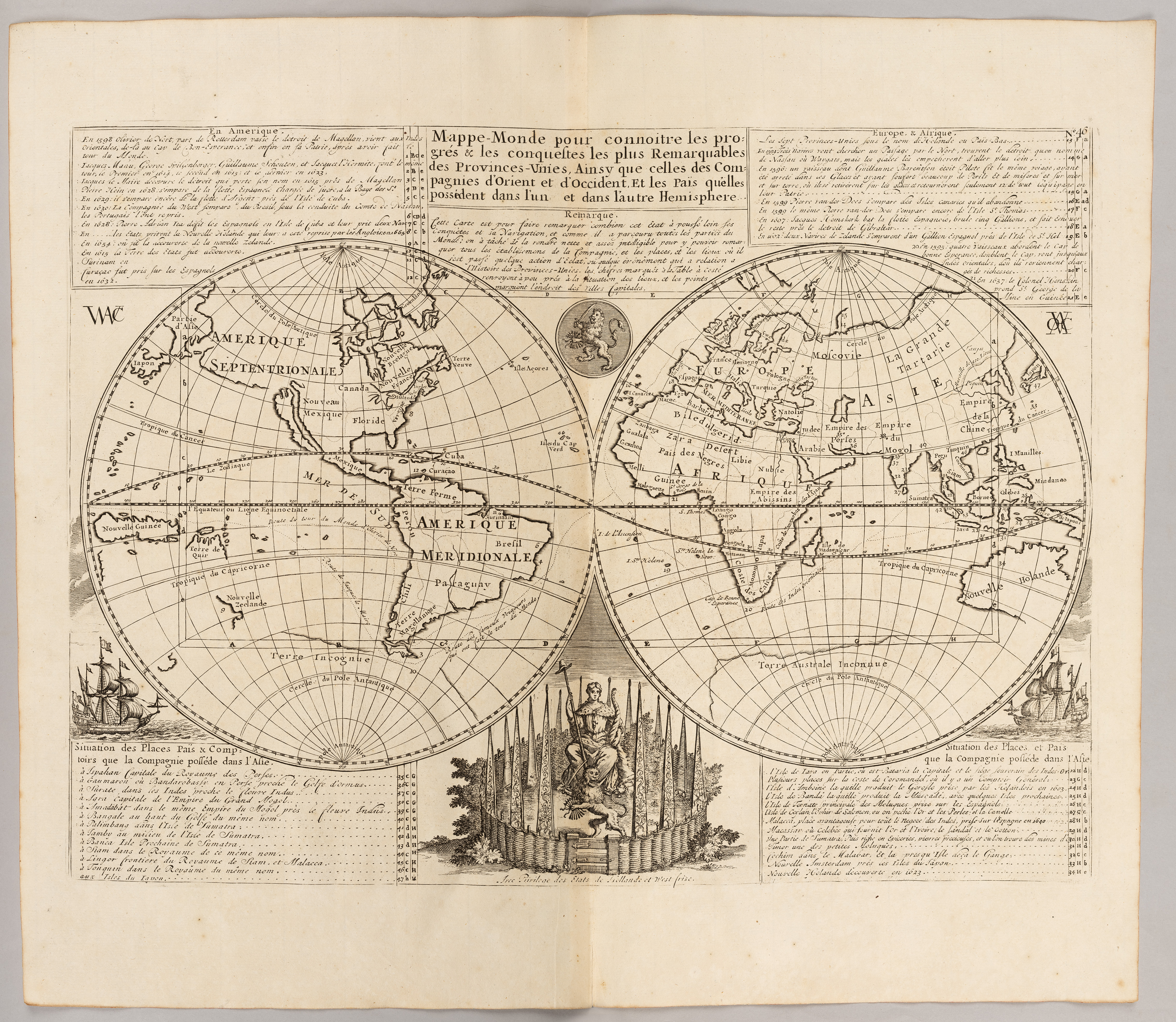
edit| Henri Chatelain: Mappemonde pour connoitre les progrés & les conquestes […] des Provinces-Unies
( |
|||||||||||||||||||||||||||
|---|---|---|---|---|---|---|---|---|---|---|---|---|---|---|---|---|---|---|---|---|---|---|---|---|---|---|---|
| Artist |
|
||||||||||||||||||||||||||
| Title |
Mappemonde pour connoitre les progrés & les conquestes […] des Provinces-Unies |
||||||||||||||||||||||||||
| Description |
Français : Réalisé par des protestants français contraints d’émigrer à Amsterdam, cet atlas ne pouvait que mettre en valeur la fortune acquise par la république des Provinces-Unies, grande puissance européenne du 17e siècle. Cette puissance est principalement fondée sur l’exploitation économique de colonies lointaines par la célèbre compagnie des Indes Orientales (VOC) et sa sœur des Indes occidentales (WC). La carte montre cette expansion mondiale de l’influence néerlandaise. 47 numéros y indiquent en effet les comptoirs, les pays contrôlés et quelques faits marquants. La domination est particulièrement visible en Indonésie : la VOC contrôle alors l’intégralité de l’archipel et exploite directement les peuples et les richesses de ces îles. - Bibliothèque municipale de Lyon, mis en ligne sur Numelyo |
||||||||||||||||||||||||||
| Date | 1721 | ||||||||||||||||||||||||||
| Medium | Gravure | ||||||||||||||||||||||||||
| Collection |
|
||||||||||||||||||||||||||
| Current location |
Bibliothèque de la Part-Dieu |
||||||||||||||||||||||||||
| Accession number | |||||||||||||||||||||||||||
| Place of creation | Amsterdam | ||||||||||||||||||||||||||
| Source/Photographer |
|
||||||||||||||||||||||||||
| Permission (Reusing this file) |
|
||||||||||||||||||||||||||


Licensing
edit
| This file is made available under the Creative Commons CC0 1.0 Universal Public Domain Dedication. | |
| The person who associated a work with this deed has dedicated the work to the public domain by waiving all of their rights to the work worldwide under copyright law, including all related and neighboring rights, to the extent allowed by law. You can copy, modify, distribute and perform the work, even for commercial purposes, all without asking permission.
|
File history
Click on a date/time to view the file as it appeared at that time.
| Date/Time | Thumbnail | Dimensions | User | Comment | |
|---|---|---|---|---|---|
| current | 09:43, 14 May 2024 | | 4,531 × 3,936 (6.67 MB) | Fadekha (talk | contribs) | Uploaded a work by Henri-Abraham Châtelain from HENRI-ABRAHAM CHATELAIN (1684-1743), NICOLAS GUEUDEVILLE (1652-1721 ?), Atlas historique, Amsterdam : L’Honoré & Chatelain, 1721, tome 1, planche 46. with UploadWizard |
You cannot overwrite this file.
File usage on Commons
The following page uses this file:
File usage on other wikis
The following other wikis use this file:
- Usage on fr.wikipedia.org