File:Back River Hayes River confluence.jpg

Size of this preview: 800 × 568 pixels. Other resolutions: 320 × 227 pixels | 640 × 455 pixels | 1,024 × 727 pixels | 1,280 × 909 pixels.
Original file (1,280 × 909 pixels, file size: 348 KB, MIME type: image/jpeg)
Captions
Captions
Add a one-line explanation of what this file represents
Summary
edit| Description |
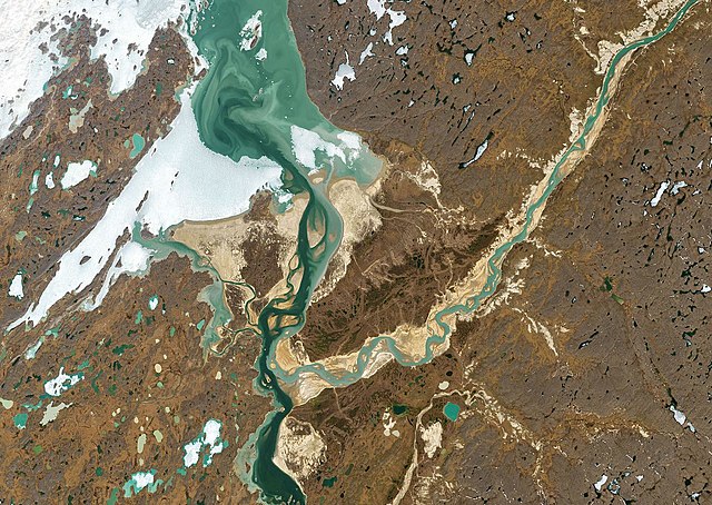
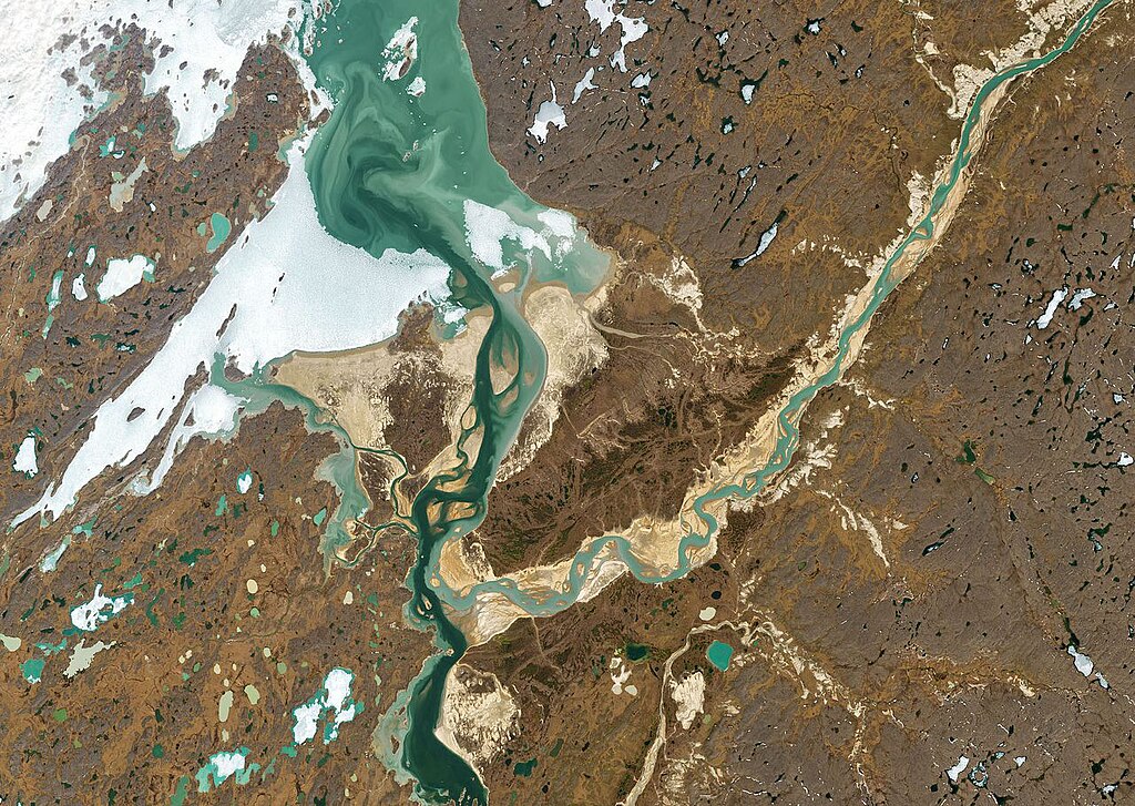
Two rivers in Nunavut, Canada, become a single unit without losing their individual appearance as they move sinuously across the tundra. The darker Back River flows north toward the Arctic Ocean. Along the way, its tributary, the Hayes River, a light, milky blue, joins it but remains visually distinct for about 10 miles beyond the confluence. Only when the merged rivers enter their final destination of Chantrey Inlet do the waters begin to blend. This phenomenon of two rivers that are joined yet distinct is the result of conditions upstream, including differences in density and velocity. The Back River flows briskly for nearly 1,000 miles, over rapids, waterfalls, and other features, through a flat landscape dominated by moss and lichen. As a result, its water remains relatively clear. The Hayes, however, runs through areas of active erosion, and is full of silt, clay, and other material it picks up along its 200-mile course to where it meets the Back. |
|||||
| Date | before 2021 | |||||
| Source | https://www.atlasobscura.com/articles/back-hayes-river-confluence-nunavut | |||||
| Author | JOSHUA STEVENS/NASA EARTH OBSERVATORY | |||||
| Permission (Reusing this file) |
|

File history
Click on a date/time to view the file as it appeared at that time.
| Date/Time | Thumbnail | Dimensions | User | Comment | |
|---|---|---|---|---|---|
| current | 16:43, 24 April 2023 | | 1,280 × 909 (348 KB) | Tillman (talk | contribs) | {{Information |Description= Two rivers in Nunavut, Canada, become a single unit without losing their individual appearance as they move sinuously across the tundra. The darker Back River flows north toward the Arctic Ocean. Along the way, its tributary, the Hayes River, a light, milky blue, joins it but remains visually distinct for about 10 miles beyond the confluence. Only when the merged rivers enter their final destination of Chantrey Inlet do the waters begin to blend. This phenomenon o... |
You cannot overwrite this file.
File usage on Commons
There are no pages that use this file.
File usage on other wikis
The following other wikis use this file:
- Usage on en.wikipedia.org