File:Bahnstrecke Salzwedel-Diesdorf MN.png

Size of this preview: 800 × 438 pixels. Other resolutions: 320 × 175 pixels | 640 × 350 pixels | 1,218 × 667 pixels.
Original file (1,218 × 667 pixels, file size: 574 KB, MIME type: image/png)
Captions
Captions
Add a one-line explanation of what this file represents
Summary edit
| Description |
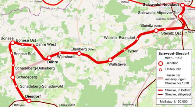
Deutsch: Karte der Bahnstrecke Salzwedel-Diesdorf. |
| Date | |
| Source | Own work, using * OpenStreetMap data for the background. |
| Author | Grauer Elefant, Openstreetmap contributers |
| Other versions | File:Bahnstrecke_Salzwedel-Diesdorf.png |
Licensing edit
I, the copyright holder of this work, hereby publish it under the following licenses:

|
Permission is granted to copy, distribute and/or modify this document under the terms of the GNU Free Documentation License, Version 1.2 or any later version published by the Free Software Foundation; with no Invariant Sections, no Front-Cover Texts, and no Back-Cover Texts. A copy of the license is included in the section entitled GNU Free Documentation License. |
This file is licensed under the Creative Commons Attribution 3.0 Unported license.
- You are free:
- to share – to copy, distribute and transmit the work
- to remix – to adapt the work
- Under the following conditions:
- attribution – You must give appropriate credit, provide a link to the license, and indicate if changes were made. You may do so in any reasonable manner, but not in any way that suggests the licensor endorses you or your use.
You may select the license of your choice.
File history
Click on a date/time to view the file as it appeared at that time.
| Date/Time | Thumbnail | Dimensions | User | Comment | |
|---|---|---|---|---|---|
| current | 15:17, 25 November 2014 | | 1,218 × 667 (574 KB) | Grauer Elefant (talk | contribs) | zweiter Halbgeviertstrich |
| 14:02, 24 November 2014 |  | 1,218 × 663 (570 KB) | Grauer Elefant (talk | contribs) | Halbgeviertstrich | |
| 19:55, 18 November 2014 |  | 1,219 × 665 (572 KB) | Grauer Elefant (talk | contribs) | Tippfehler ausgebessert | |
| 18:46, 18 November 2014 |  | 1,219 × 666 (573 KB) | Grauer Elefant (talk | contribs) | == {{int:filedesc}} == {{Information |Description ={{de|1=Karte der Bahnstrecke Salzwedel-Diesdorf.}} |Source ={{own}}, using * OpenStreetMap data for the background. |Author =Grauer Elefant, Openstreetmap... |
You cannot overwrite this file.
File usage on Commons
The following 4 pages use this file:
File usage on other wikis
The following other wikis use this file:
- Usage on de.wikipedia.org
- Usage on www.wikidata.org