File:Bahrain municipalities numbered.png
No higher resolution available.
Bahrain_municipalities_numbered.png (150 × 245 pixels, file size: 7 KB, MIME type: image/png)
Captions
Captions
Add a one-line explanation of what this file represents
| Description |
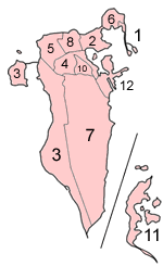
Map of the municipalities of Bahrain (which existed until 2002), numbered in English alphabetical order (using a straight transliteration, rather than translation)
|
| Date | |
| Source | Self-made, traced from public domain UN or CIA maps, with information from the Bahrain government. |
| Author | User:Golbez |
| Other versions | The current map of Bahrain is at Image:Bahrain governorates numbered.png. |
I, the copyright holder of this work, hereby publish it under the following licenses:
This file is licensed under the Creative Commons Attribution-Share Alike 2.5 Generic, 2.0 Generic and 1.0 Generic license.
- You are free:
- to share – to copy, distribute and transmit the work
- to remix – to adapt the work
- Under the following conditions:
- attribution – You must give appropriate credit, provide a link to the license, and indicate if changes were made. You may do so in any reasonable manner, but not in any way that suggests the licensor endorses you or your use.
- share alike – If you remix, transform, or build upon the material, you must distribute your contributions under the same or compatible license as the original.

|
Permission is granted to copy, distribute and/or modify this document under the terms of the GNU Free Documentation License, Version 1.2 or any later version published by the Free Software Foundation; with no Invariant Sections, no Front-Cover Texts, and no Back-Cover Texts. A copy of the license is included in the section entitled GNU Free Documentation License. |
| This file is licensed under the Creative Commons Attribution-Share Alike 3.0 Unported license. | ||
| ||
| This licensing tag was added to this file as part of the GFDL licensing update. |
You may select the license of your choice.
File history
Click on a date/time to view the file as it appeared at that time.
| Date/Time | Thumbnail | Dimensions | User | Comment | |
|---|---|---|---|---|---|
| current | 05:51, 18 December 2004 | | 150 × 245 (7 KB) | Golbez (talk | contribs) | Map of Bahrain showing municipalities. Made by User:Golbez. {{GFDL}} |
You cannot overwrite this file.
File usage on Commons
The following 3 pages use this file:
File usage on other wikis
The following other wikis use this file:
- Usage on ar.wikipedia.org
- البحرين
- المحرق (مدينة)
- محافظة العاصمة (البحرين)
- محافظة المحرق
- الشمالية (محافظة)
- جنوبية (محافظة)
- قالب:محافظات البحرين
- المحافظة الوسطى (البحرين)
- محافظات البحرين
- مدينة عيسى
- الحد (مدينة)
- جزر حوار
- ويكيبيديا:مشروع ويكي البحرين
- بوابة:البحرين
- بوابة:البحرين/قوالب
- بريد البحرين
- البلديات السابقة في البحرين
- المنطقة الوسطى (البحرين)
- الرفاع والمنطقة الجنوبية (البحرين)
- المنطقة الغربية (البحرين)
- Usage on el.wikipedia.org
- Usage on en.wikipedia.org
- Manama
- Central Governorate, Bahrain
- Capital Governorate, Bahrain
- Muharraq Governorate
- Northern Governorate
- Southern Governorate
- Al Hidd
- Western Region, Bahrain
- Rifa and Southern Region, Bahrain
- Isa Town
- Central Region, Bahrain
- Northern Region, Bahrain
- Muharraq
- Template:Governorates of Bahrain
- Former regions of Bahrain
- Bahrain
- Governorates of Bahrain
- Portal:Bahrain
- Portal:Bahrain/Topics
- Usage on eo.wikipedia.org
- Usage on eu.wikipedia.org
- Usage on fr.wikipedia.org
- Usage on gl.wikipedia.org
- Usage on hy.wikipedia.org
- Usage on id.wikipedia.org
- Usage on incubator.wikimedia.org
- Usage on is.wikipedia.org
- Usage on it.wikipedia.org
View more global usage of this file.