File:Bailiff Bridge Station site of 1764486 ffe9527d.jpg
No higher resolution available.
Bailiff_Bridge_Station_site_of_1764486_ffe9527d.jpg (640 × 345 pixels, file size: 90 KB, MIME type: image/jpeg)
Captions
Captions
Add a one-line explanation of what this file represents
Summary
edit
| Description |
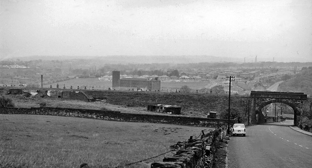
English: Site of Bailiff Bridge Station. View west on A649 to site of Bailiff Bridge Station, which was closed right back on 2/4/17 (!), on the loop line (Pickle Bridge Branch) connecting Huddersfield (Bradley Wood Junction) with Bradford via Wyke Junction, by-passing Halifax; the line ceased to carry local passenger trains on 14/9/31, through trains in 6/48 and freight on 4/8/52. The formation (if not the railway) was still there when I took this photograph. |
| Date | |
| Source | From geograph.org.uk |
| Author | Ben Brooksbank |
| Permission (Reusing this file) |
Creative Commons Attribution Share-alike license 2.0 |
| Camera location | | View this and other nearby images on: OpenStreetMap |
|---|
Licensing
edit

|
This image was taken from the Geograph project collection. See this photograph's page on the Geograph website for the photographer's contact details. The copyright on this image is owned by Ben Brooksbank and is licensed for reuse under the Creative Commons Attribution-ShareAlike 2.0 license.
|
This file is licensed under the Creative Commons Attribution-Share Alike 2.0 Generic license.
Attribution: Ben Brooksbank
- You are free:
- to share – to copy, distribute and transmit the work
- to remix – to adapt the work
- Under the following conditions:
- attribution – You must give appropriate credit, provide a link to the license, and indicate if changes were made. You may do so in any reasonable manner, but not in any way that suggests the licensor endorses you or your use.
- share alike – If you remix, transform, or build upon the material, you must distribute your contributions under the same or compatible license as the original.
File history
Click on a date/time to view the file as it appeared at that time.
| Date/Time | Thumbnail | Dimensions | User | Comment | |
|---|---|---|---|---|---|
| current | 16:09, 26 January 2011 | | 640 × 345 (90 KB) | Belaro (talk | contribs) | == {{int:filedesc}} == {{Information |Description={{en|1=Site of Bailiff Bridge Station View west on A649 to site of Bailiff Bridge Station, which was closed right back on 2/4/17 (!), on the loop line (Pickle Bridge Branch) connecting Huddersfield (Bradle |
You cannot overwrite this file.
File usage on Commons
The following page uses this file:
File usage on other wikis
The following other wikis use this file:
- Usage on en.wikipedia.org
- Usage on www.wikidata.org