File:Baja California fire amo 2019297.jpg

Size of this preview: 800 × 533 pixels. Other resolutions: 320 × 213 pixels | 640 × 427 pixels | 1,024 × 683 pixels | 1,280 × 853 pixels | 2,862 × 1,908 pixels.
Original file (2,862 × 1,908 pixels, file size: 2.03 MB, MIME type: image/jpeg)
Captions
Captions
Add a one-line explanation of what this file represents
Summary edit
| Description |
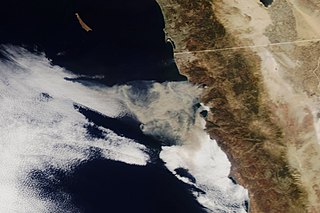
English: In Mexico, a fire broke out on October 24 along the northwest coast between Tijuana and Enseneda, near the beach resort town of Rosarito. By the end of the day, the smoky fire had spread across 7,100 acres and was 25 percent contained, according to the Baja California Civil Protection Office. The Moderate Resolution Imaging Spectroradiometer (MODIS) instruments on NASA’s Terra and Aqua satellites acquired image of the fires in the early afternoon of October 24. |
| Date | |
| Source |
MODIS https://earthobservatory.nasa.gov/images/145787/winds-drive-smoky-wildfires-in-california-mexico |
| Author | NASA |
Licensing edit
| This file is in the public domain in the United States because it was solely created by NASA. NASA copyright policy states that "NASA material is not protected by copyright unless noted". (See Template:PD-USGov, NASA copyright policy page or JPL Image Use Policy.) | ||
 |
Warnings:
|
File history
Click on a date/time to view the file as it appeared at that time.
| Date/Time | Thumbnail | Dimensions | User | Comment | |
|---|---|---|---|---|---|
| current | 07:19, 27 October 2019 | | 2,862 × 1,908 (2.03 MB) | Sevgonlernassau (talk | contribs) | User created page with UploadWizard |
You cannot overwrite this file.
File usage on Commons
The following page uses this file: